
EAGLE COUNTY 1041 REVIEW
WHITNEY RESERVOIR
Evidence, Applicable Approval Standards and Save Homestake’s Position
EXECUTIVE EVIDENCE OVERVIEW
The evidence at a glance
A connected record of place, water and ecological function. Each evidence category leads to a question the County must answer under its applicable approval standards.
Wetlands + fens
Dated inventory polygons intersect all four modeled alternatives. Peat, groundwater and vegetation function together.
§6.04.01(16), (17), (19), (20)
Water + existing export
23,371 AF/year average recorded Tunnel export and 21,498 AF/year passing Gold Park, WY2007-2024.
§6.04.01(15), (16); §6.04.02(3)
Wildlife + aquatic habitat
Historical toad breeding and cutthroat records, current observations and studies of water-dependent habitat.
§6.04.01(18), (19)
The complete project
The reservoir connects to dam works, roads, pumping, conveyance, power and recurring maintenance.
§6.01.09; §6.03.06; §6.04.01(17)-(21)
Recreation + landscape
Existing trail, river and wildlife-viewing experience; construction and operating noise, access and scenery.
§6.04.01(11), (14), (21)
Need + efficient water use
Credit verified conservation and reuse. Compare further practical savings and reliable annual supply on the same basis.
§6.04.02(1), (3); §6.04.01(5), (24)
Evidence: S01. Full titles and pinpoints in the evidence register.
ATTRIBUTED ADVOCACY
Save Homestake’s position
Save Homestake opposes Whitney Reservoir, new or expanded interbasin diversions from Homestake Valley, and changes to the Holy Cross Wilderness boundary. The requested outcome is the organization’s conclusion from this evidence.
The criteria supporting that position
- Wetlands, groundwater, plants and soils: preserve the functioning peat, water and living community, including habitat exposed to modeled inundation and construction.
- Wildlife and aquatic life: protect breeding, seasonal movement, cold-water habitat and the flow-dependent food web.
- Recreation, scenery and nuisance: evaluate the complete construction and operating landscape, including roads, pumps, power and maintenance.
- Necessity, efficient use and County benefits: demonstrate reliable project-specific supply, credit conservation already achieved, and compare additional practical measures and local resource losses.
A decision grounded in the governing record
The Board determines compliance. The chapters distinguish recorded facts, measurements, calculations, models and scientific inference from Save Homestake’s analysis and requested findings. County findings are described as such only where an actual County decision exists.
Evidence: S01 · S07 · S08 · S31. Full titles and pinpoints in the evidence register.
HOW TO READ THIS DOSSIER
A record you can inspect
Start with the evidence overview and matrix. Each criterion chapter follows the same sequence: the resource; governing code; evidence; material open questions; why it matters; Save Homestake’s position; the Board’s decision; and sources.
| Evidence category | Meaning in this dossier |
|---|---|
| DOCUMENTED FACT | A dated source directly records the fact. |
| MEASURED DATA | An observation or instrument record, with location and period. |
| CALCULATION | A reproducible transformation of stated inputs. |
| MODELED RESULT | An output dependent on identified geometry, scenarios and assumptions. |
| SCIENTIFIC INFERENCE | A mechanism supported by research, applied with its study setting. |
| PROPONENT STATEMENT | The cities’ or applicant’s own attributed project description. |
| SAVE HOMESTAKE ANALYSIS | The project’s interpretation connecting sources and approval questions. |
| SAVE HOMESTAKE POSITION | The organization’s clearly attributed requested decision. |
| UNRESOLVED | A material record that still needs an identified answer. |
Read citations in one consistent way
S01-S34 are established dossier source labels, with canonical project identifiers 1041:S01 through 1041:S34. HWF prefixes preserve ecology source and claim IDs; HWA identifies water-audit sources. MUN identifies municipal sources. Source IDs link directly to the original record; the full register provides titles and pinpoints. Chapter and matrix page numbers link inside this PDF.
Current law is the published adopted Chapter VI. September 15, 2026 provisions are a proposed comparison. Appendix A supplies considerations for applying the criteria, rather than additional mandatory approval standards.
Evidence: S01 · S02. Full titles and pinpoints in the evidence register.
EXECUTIVE MATRIX · 1 OF 2
The decision roadmap
Current criteria govern. Draft counterparts below refer only to the September 15, 2026 proposed text; related provisions can differ in wording and scope.
| Resource / issue | Key evidence | Current code | Proposed comparison | Decision question | Save Homestake position | Detail |
|---|---|---|---|---|---|---|
| Fens / wetlands | All alternatives intersect dated wetland/fen polygons; peat function. | 6.04.01(17) | 406(C)(3); 307(F) | Will functions avoid significant degradation after conditions? | Deny if significant loss remains. | Read chapter · PDF p.24 |
| Groundwater | Groundwater-fed peat; excavation, dewatering and channel connections. | 6.04.01(16), (17), (20) | 406(C)(2)-(3) | Which sources, levels and functions would change? | Protect the supply sustaining peat and habitat. | Read chapter · PDF p.26 |
| Surface water / aquatic life | Matched annual accounts; seasonal flow, metals and food-web studies. | 6.04.01(15), (18) | 406(C)(1), (4) | What incremental quality and habitat change would occur? | Deny significant degradation left unresolved. | Read chapter · PDF p.30 |
| Wildlife / plants / soils | Historical records, observations, regional ecological studies. | 6.04.01(18)-(20) | 411-413 | Which communities/functions are exposed and replaceable? | Protect connected habitat and lasting peat function. | Read chapter · PDF p.33 |
| Recreation / scenery | Existing valley uses; modeled landscape and basin boating scenarios. | 6.04.01(11), (14) | 423; 431 | Would existing experience or visual quality significantly decline? | Evaluate existing experience and full operating levels. | Read chapter · PDF p.43 |
| Noise / infrastructure | Applicant pumping/conveyance; dam, roads, power and maintenance. | 6.04.01(21); 6.03.06 | 429; 425-426 | Will construction or operation cause an unresolved nuisance? | Review every connected component and operating phase. | Read chapter · PDF p.45 |
Evidence: S01 · S02. Full titles and pinpoints in the evidence register.
EXECUTIVE MATRIX · 2 OF 2
The decision roadmap
Current criteria govern. Draft counterparts below refer only to the September 15, 2026 proposed text; related provisions can differ in wording and scope.
| Resource / issue | Key evidence | Current code | Proposed comparison | Decision question | Save Homestake position | Detail |
|---|---|---|---|---|---|---|
| Necessity | Storage concepts and broader program objective; service-area demand. | 6.04.02(3) | Information: 303(D), 331(B); test omitted | Is Whitney necessary under reasonable service-area assumptions? | Require dependable Whitney-only yield and a common baseline. | Read chapter · PDF p.49 |
| Efficient water use | Measured conservation/reuse plus practical additional savings. | 6.04.02(1) | 434(D); 331 materials | Does the project emphasize the most efficient water use? | Credit progress and quantify additional measures. | Read chapter · PDF p.51 |
| Dependable supply | Refill, dry years, senior rights, pumping and releases. | 6.04.01(5); 6.04.02(3) | 403; 409 | Are operation and promised deliveries feasible and dependable? | Require an auditable water balance and enforceable operations. | Read chapter · PDF p.54 |
| County benefits / economy | Binding County benefits versus permanent resource/opportunity losses. | 6.04.01(24), (10), (9) | 422; no equivalent standalone (24) | Do County benefits outweigh County losses? | Apply each retained standard; restore the current balancing test. | Read chapter · PDF p.56 |
| Cultural / historic | Protected landscape history; inventory needed for affected resources. | 6.04.01(22) | 424 | Which important areas would be significantly degraded? | Protect documented resources with meaningful Tribal participation. | Read chapter · PDF p.47 |
| Rights / public lands | Ownership, protected boundaries, approvals and water decrees. | 6.04.01(1); 6.01.05 | 404; 109 | Are all rights/approvals secured and standards met? | Oppose wilderness-boundary changes; enforce County protections. | Read chapter · PDF p.58 |
Evidence: S01 · S02. Full titles and pinpoints in the evidence register.
CLICKABLE CONTENTS
Find your way through the record
The executive matrix links each approval issue to its criterion chapter. These contents lead to the supporting systems, maps, studies and original records.
Decision rule and crosswalk
The Board decides. Every standard must be met.
The Eagle County Board of County Commissioners is the 1041 Permit Authority under §6.01.07(1). Current §6.03.10 places the burden on the applicant. The Board may deny or impose conditions that ensure compliance; §6.04.01 requires denial or approval with such conditions for a noncompliant project. State §24-65.1-501(4) requires denial when the activity does not comply. A failed criterion that remains unresolved supports denial.
Draft §§211 and 401 preserve the applicant’s burden. Section 211(B) requires denial for any failed Article 4 standard; §211(C) permits conditions that establish compliance with every standard. The Board must evaluate the mitigation actually offered and the harm that remains.
| Protected interest | Current code | September draft |
|---|---|---|
| Fens / wetlands | 6.04.01(17) | 406(C)(3); 307(F) |
| Groundwater | 6.04.01(16) | 406(C)(2) |
| Surface water / aquatic life | 6.04.01(15), (18) | 406(C)(1), (4) |
| Wildlife / plants | 6.04.01(18), (19) | 411; 412 |
| Recreation / local economy | 6.04.01(11), (10) | 423; 422 |
| County benefits exceed losses | 6.04.01(24) | No equivalent standalone test |
| Demonstrated necessity | 6.04.02(3) | Information required; test omitted |
| Efficient use / conservation | 6.04.02(1); 6.04.01(12) | 434(D); 331 materials |
| Feasibility / dependable supply | 6.04.01(5); 6.04.02(3) | 403; 409 |
| Nuisance / scenery | 6.04.01(21), (14) | 429; 431 |
| Historic / archaeological areas | 6.04.01(22) | 424 |
| Rights and approvals | 6.04.01(1) | 404 |
Crosswalk entries identify related protections, not identical language. Current Appendix A lists optional considerations supporting the criteria; it is not a second set of mandatory approval standards.
Evidence: S01 · S02 · S06. Full titles and pinpoints in the evidence register.
Status checked September 23, 2026
Which code governs the decision?
| Step | Verified status on September 23, 2026 |
|---|---|
| September 23 planning commissions | Recommendation hearing scheduled. Posted resolution templates have blank vote and signature fields; a completed recommendation was not verified. |
| October 27 Board hearing | Scheduled 2:30-4 p.m. for consideration of 1041 amendments. |
| Effective date / transition | Staff recommends effectiveness with readopted ECLUR, with current Chapter VI fully effective until then. No enacted replacement effective date was verified. |
| Broader code / map hearing | Separate November 3 schedule retained in the County’s broader adoption materials. |
The draft crosswalk is a comparison with the September 15 proposal. Apply an enacted replacement only after verifying its final text, applicability, transition and effective-date resolution.
The original records stay visible
Current-code, draft and staff excerpts are reproduced in the exhibits. Source IDs distinguish the enacted code, proposed text, hearing schedule and staff recommendation.
Evidence: S01 · S02 · S03 · S04 · S23. Full titles and pinpoints in the evidence register.
The complete project
Whitney’s impact extends beyond the waterline
Colorado Springs Utilities describes gravity pipelines and tunnels collecting from Peterson, Fall and Resolution Creeks, followed by pumping Whitney water up to existing Homestake Reservoir (March 2022 fact sheet, p. 1, S08). The utility’s 2019 draft map shows the broader conveyance concepts (S29). These records establish a connected water system with construction and operating effects throughout the valley.
The argument for denial
Inundation permanently converts habitat. Building and operating the supporting system adds clearing, excavation, road use, visible infrastructure and recurring activity. Those effects can reach wetlands outside the flood line, groundwater connections, wildlife movement and the places people come to enjoy. They belong in the same compliance findings as the reservoir itself.
How both codes reach the whole project
Current §6.03.06 requires the project and impact record, including alternatives and construction/operation effects. Current definitions include systems and related components. Draft §109 expressly includes required support facilities, activities and components, with direct, indirect and cumulative County land-use effects.
How to read the maps
The utility map preserves its draft conveyance routes. The alternative maps use the existing reservoir model and complete archived wetland inventories. They show the modeled dam embankment and mark likely downstream work locations with callouts. Pump-station sites, permanent access layouts and electrical routes await a located design in the public record; the component tables account for their effects without assigning invented locations.
Evidence: S01 · S02 · S08 · S09 · S29. Full titles and pinpoints in the evidence register.
Original project evidence · CSU, 2019
The utility’s wider conveyance concept
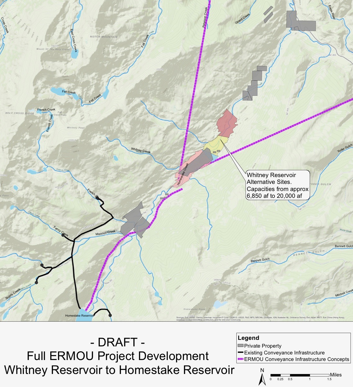
Original utility map reproduced by Aspen Journalism, July 17, 2019 (S29). Its draft routes show why collection and uphill conveyance belong in the County’s impact review. CSU’s 2022 fact sheet supplies the later description of tributary pipelines/tunnels and pumping (S08, p. 1).
Evidence: S29 · S08. Full titles and pinpoints in the evidence register.
Construction footprint and retained works
Roads and downstream dam works
The 2019 applicant map locates the four alternative dam axes, Homestake Creek and the existing road (S09, Figure 1, technical p. 3 / PDF p. 11). The maps that follow show the modeled embankment and the downstream side where related work would occur. The effects below are anticipated construction pathways tied to those components.
| Component and basis | Likely construction effects | Continuing effects |
|---|---|---|
| Dam, foundations and downstream works Mapped alternative axes; modeled embankments. | Clearing and excavation; downstream toe, outlet/spillway work; temporary stream management; equipment access; sediment and groundwater disturbance. | Visible dam and outlet works; inspections, repair access and altered channel/flow conditions. |
| Homestake Road and work/service access Existing road mapped in S09. | Haul traffic, dust and equipment; new or relocated road cuts/fills where selected; potential wetland crossings and temporary access interruptions along affected routes. | Service vehicles; road/drainage upkeep; recurring access needs and any operating restrictions. |
| Staging, materials and excavated spoil Anticipated dam/conveyance work. | Laydown, stockpiles, material handling and runoff. Locate each temporary site against wetlands and groundwater connections. | Retained access or pads; reclamation performance; disturbance when repairs require renewed work areas. |
Apply current wetlands, wildlife, plants/soils, recreation, nuisance and visual criteria: §6.04.01(17)-(21), (11), (14). Draft counterparts include §§406, 411-413, 423, 429-432; §§425-426 also address traffic and road costs. The 2019 drilling-access drawings describe temporary investigation access.
Evidence: S01 · S02 · S09 · S27. Full titles and pinpoints in the evidence register.
The operating system
Pumping, power and maintenance count
Pumping and water conveyance are explicit in CSU’s description (S08, p. 1). Energy supply, service access and maintenance are necessary to operate that system. Their anticipated effects must be assessed through the selected equipment and layout.
| Component and basis | Construction effects | Operation and maintenance |
|---|---|---|
| Pump facilities Uphill pumping described by CSU. | Foundation/pad, pipe connections, equipment installation, access and energy supply. | Pump/motor and ventilation noise; vibration; visible buildings, lighting and equipment; service trips, inspections and equipment replacement. |
| Pipelines and tunnels CSU description and draft conveyance map. | Trenching or tunnel excavation; portals/shafts where selected; spoil handling; crossings and potential groundwater interception. | Visible portals/valves; inspection access; leak repairs and replacement work that can reopen disturbed ground. |
| Electrical supply and controls Engineering requirement of pumping. | Selected cable/line corridor and equipment pads; installation access and crossings. Include poles or generation only if proposed. | Equipment appearance, transformer/fan sound where relevant, lighting, testing and servicing; corridor vegetation management where needed. |
Why the operating period matters
Initial construction is only one period of disturbance. Repeated service access, equipment operation, corridor work and repairs can recur over the project’s life. Quiet recreation, wildlife movement, views and property enjoyment must be assessed against that continuing activity.
Evidence: S01 · S02 · S08 · S09 · S29. Full titles and pinpoints in the evidence register.
MEASURED DATA + SAVE HOMESTAKE CALCULATION
Two recorded routes through Homestake
Across WY2007-2024, recorded water moving through Homestake Tunnel exceeded the volume recorded passing the Gold Park stream gauge. The comparison describes the scale of those two routes over the same 18 water years.
- Average recorded Homestake Tunnel export · AF / YEAR
- 23,371
- Average recorded passing Gold Park · AF / YEAR
- 21,498
The denominator is explicit
Tunnel export ÷ (Tunnel export + Gold Park flow). Gold Park gauges a 35.6-square-mile drainage. This is a comparison across two recorded routes, not a verified percentage of all natural Homestake runoff.
| WY2007-2024 route | Total recorded volume | Share of these routes |
|---|---|---|
| Homestake Tunnel | 420,676.93 AF | 52.09% |
| Passing Gold Park | 386,968.01 AF | 47.91% |
| Two-route sum | 807,644.94 AF | 100.00% |
Why it matters: existing export is already a major part of the recorded water movement in the upper valley. A Whitney operating proposal should be assessed against that measured setting and the seasonal water sustaining downstream habitat.
Evidence: HWA:S-GP-ANNUAL · HWA:S-USGS-GP · HWA:S-TUNNEL · HWA:S-REPORT. Full titles and pinpoints in the evidence register.
REPRODUCIBLE WATER ACCOUNTING
The arithmetic and its boundaries
Gold Park: matched 18-year comparison
Export share = 420,676.9294 ÷ (420,676.9294 + 386,968.00661157) × 100 = 52.086865%. Annual means divide each total by 18 water years. WY2007-2024 is one shared period, not a mixture of unmatched records.
A partial balance, kept separate
Adding endpoint reservoir storage change and recorded evaporation accounts yields an export comparison near 51.75%. This adds known terms to the balance; unresolved physical terms still prevent a fully naturalized estimate of total runoff.
Red Cliff: a different question
The Red Cliff comparison is approximately 43% across two measured paths during WY2007-2011. Red Cliff has a larger downstream drainage and a shorter period, with additional downstream contributions. Its result is a separate comparison, not the low end of an uncertainty range around Gold Park.
Five intakes: collection within the system
| Collector | Recorded average capture, WY2014-2024 |
|---|---|
| French | ~3,531 AF/year |
| Fancy | ~1,780 AF/year |
| Missouri | ~1,743 AF/year |
| Sopris | ~2,486 AF/year |
| East Fork | ~3,610 AF/year |
| Combined record | ~13,149 AF/year |
The combined mean is calculated from the unrounded collector records. The five displayed rounded means sum to 13,150 AF/year. Collector water overlaps later reservoir/Tunnel accounting and is never added to Tunnel export as another withdrawal.
Evidence: HWA:S-GP-ANNUAL · HWA:S-RESERVOIR · HWA:S-REDCLIFF · HWA:S-COLLECTORS · HWA:S-RAW. Full titles and pinpoints in the evidence register.
CONNECTED SYSTEM + SCIENTIFIC INFERENCE
Water timing is habitat
Snow and rain enter headwater streams and groundwater. Seasonal water sustains fens, wet meadows, willow, beaver complexes and aquatic habitat, then moves through lower Homestake Creek toward the Eagle River. These pathways connect the water account with the living resources under review.
Connected hydrology: snow and rain → streams and groundwater → fen, meadow and willow → beaver and aquatic habitat → lower Homestake Creek and the Eagle River.
Existing collection branch: tributary intakes → Homestake Reservoir → Homestake Tunnel export.
Local records and regional mechanisms
Local evidence includes mapped wetlands, field observations and historical upper-Homestake toad breeding and trout documentation. Colorado studies show streamside vegetation shifts below diversions, slower groundwater decline around monitored beaver dams and persistent altered peat properties after drainage. Those study results explain mechanisms to measure in Homestake.
The relevant comparison is seasonal: spring inundation and recharge, breeding-water duration, summer groundwater and cold-water refuge, plus food transported by flowing water. Annual volumes establish scale; hydrographs and groundwater records connect operation to ecological function.
The approval question
For each exposed resource, compare current, no-action and project conditions at matched locations and times. Identify the water source, magnitude and duration of change, biological response and enforceable conditions under §6.04.01(15)-(20).
Evidence: HWA:S-GP-ANNUAL · HWF:V3-17 · HWF:S31 · HWF:S12 · HWF:V3-07 · HWF:V3-21. Full titles and pinpoints in the evidence register.
WHAT IS KNOWN / WHAT MUST BE RESOLVED
The supply record the decision needs
Whitney-only dependable yield
Known: CSU describes Whitney storage concepts of 6,850-20,000 AF. The broader Eagle River Joint Use project objective is up to 20,000 AF/year for the East Slope. Storage and annual supply are different quantities, and the broader objective is not Whitney-only annual yield.
| Material record | Record holder / decision value |
|---|---|
| Whitney-only annual and dry-year yield | Applicant / utilities: necessity, feasibility and alternatives on a common dependable-supply basis. |
| Initial fill, refill and source collection | Applicant: identify tributaries, diversion timing, source drainage and operating levels. |
| Evaporation, storage change and bypasses | Applicant / operators: close the physical balance and describe water available to downstream habitat. |
| Pumping, power and conveyance limits | Applicant: evaluate delivery reliability, energy, operating effects and life-cycle cost. |
| Selected footprint and complete works | Applicant: locate permanent/temporary facilities, access, maintenance and actual resource exposure. |
Why the record matters: the County can compare the reliable supply actually delivered with conservation, reuse and alternative portfolios only when the same period, reliability standard, legal availability and losses are used.
Evidence: S08 · HWA:S-REPORT · S01. Full titles and pinpoints in the evidence register.
Four alternatives · unchanged model
Mapped wetlands and potential fens in modeled flood zones
The archived inventory overlay places about 81.4 acres of mapped wetlands and potential fens inside the shared area of all four displayed flood zones. Alternatives A and D intersect four potential-fen polygons; B and C intersect two. These are inventory-model intersections using the dated older CNHP service; the source-version question is detailed on the next page.
| Alternative | Wetland polygons | Potential-fen polygons | Wetland + fen overlap¹ |
|---|---|---|---|
| A | 29 | 4 | 127.4 acres |
| B | 19 | 2 | 85.4 acres |
| C | 21 | 2 | 94.9 acres |
| D | 38 | 4 | 134.8 acres |
¹ Modeled intersection with the union of mapped wetland and potential-fen polygons, with overlapping areas counted once. Pond, river/stream and lake inventory polygons appear for context and are not added to this acreage. Values describe the existing full reservoir presets.
What the maps show
Each map shows the same extent and scale: modeled flood zone; mapped wetlands; CNHP potential fens; mapped ponds, streams and lakes; existing Homestake Road; and the modeled dam embankment. Orange downstream arrows identify the likely toe/outlet/access work vicinity. Work-area boundaries depend on the selected construction design.
Inventory classifications and coverage
All positive-area intersections were checked against the complete September 18 exports: 2,979 CNHP Colorado Wetlands features and 600 Fen Mapping features covering the model area. The four intersecting fen IDs, 3033, 3045, 5490 and 5491, are classified Potential Fen. IDs 3045 and 5491 intersect all four alternatives. Campaign field photographs and observations provide the separate local habitat record.
Method and significance
The overlay intersects the existing 10 m terrain solver’s water-surface triangles with inventory polygons in UTM Zone 13N. Model inputs, depths and presets are unchanged. These are modeled inventory-area estimates. The per-feature register lists every intersecting ID and modeled area (S31).
Evidence: S11 · S26 · S30 · S31. Full titles and pinpoints in the evidence register.
CNHP INVENTORY VERSION STATUS
A dated map, a traceable source
The September 18 spatial model uses archived full exports of the older CNHP Fen Mapping and Colorado Wetlands services. Its geometry, feature IDs and overlap calculations remain reproducible. The potential-fen classifications remain attached to the mapped features.
- In the same downstream query envelope · OLDER SERVICE FEATURES
- 18
- A newer service with different geometries · FENS 2025 FEATURES
- 6
What is known
The September 23 comparison returned different counts and geometries in the identical downstream query envelope. These counts describe records returned by two services, not habitat disappearance.
What must be resolved
CNHP / USFS should identify source currency, field basis, classification changes and correspondence between old and new polygons. The affected map layers should be updated once that relationship is established, retaining the original dated model for reproducibility.
Why the record matters
A permit decision needs a resource baseline that joins map polygons with peat measurements, vegetation, hydrology and current field condition. Source reconciliation protects the precision of both the impact acreage and the wetland/fen interpretation.
Evidence: S26 · S30 · S31 · HWF:FEN-2025. Full titles and pinpoints in the evidence register.
Modeled flood zone and downstream construction
Alternative A: wetlands and works
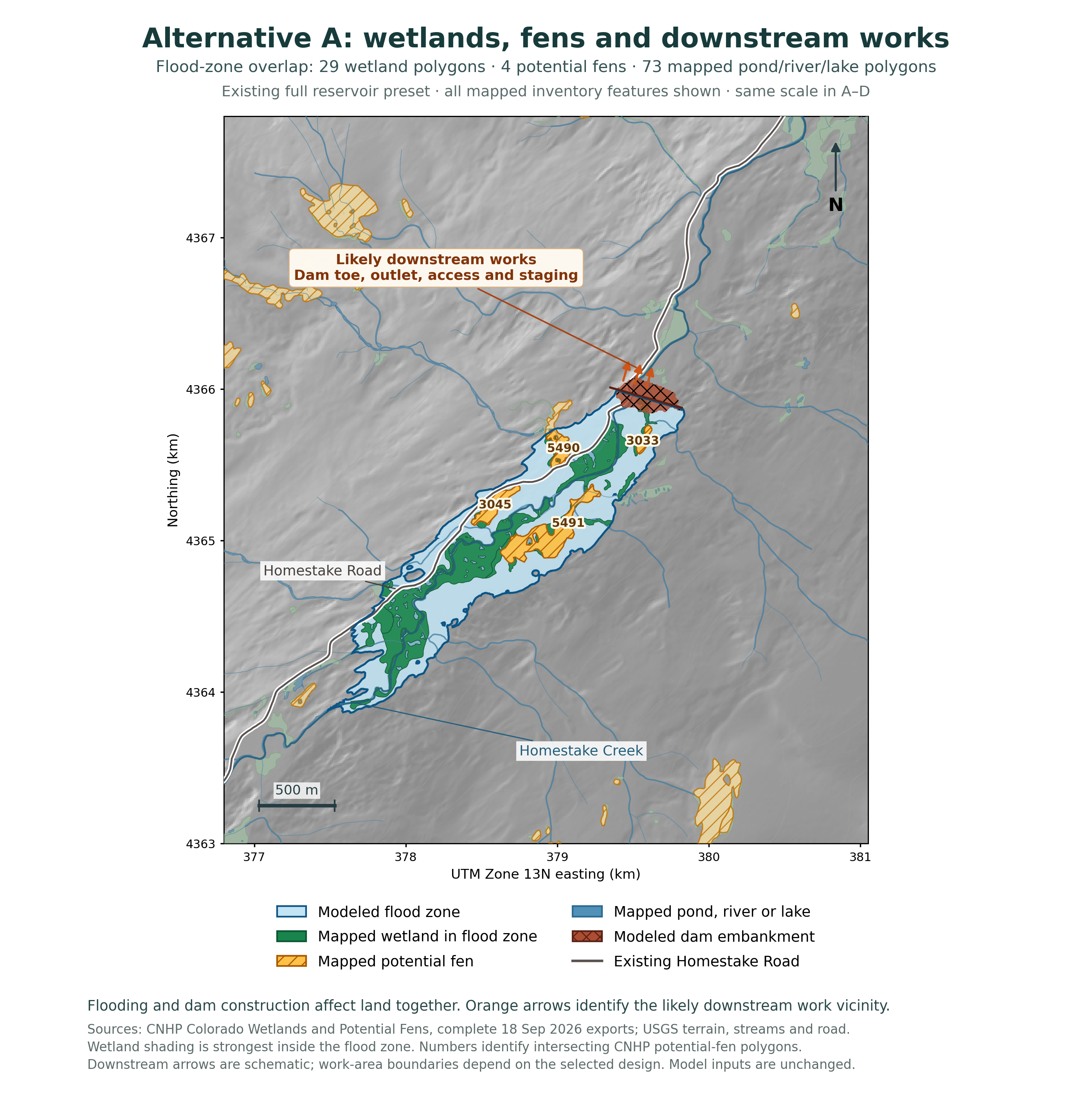
Evidence: S09 · S11 · S26 · S30. Full titles and pinpoints in the evidence register.
Modeled flood zone and downstream construction
Alternative B: wetlands and works
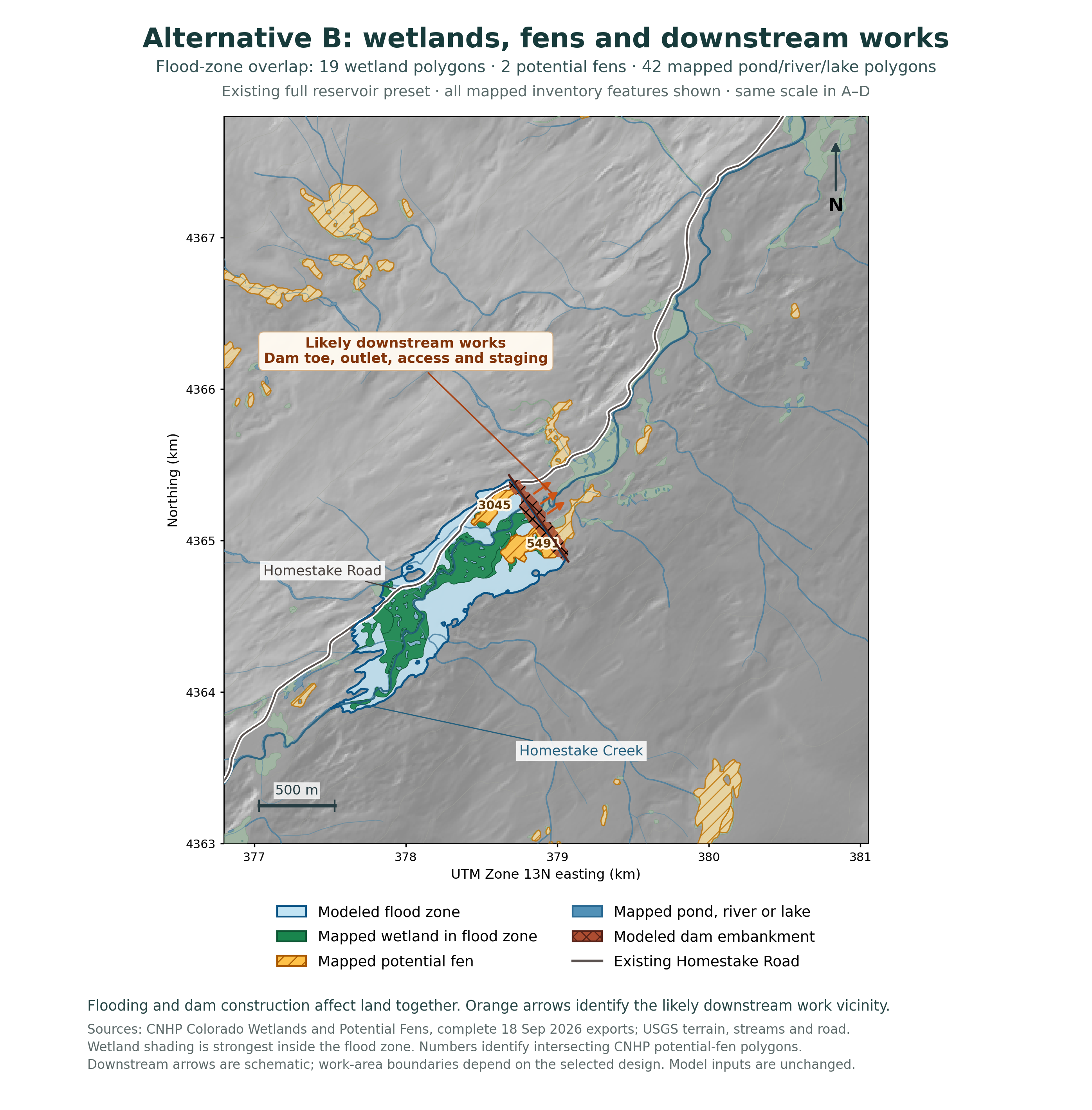
Evidence: S09 · S11 · S26 · S30. Full titles and pinpoints in the evidence register.
Modeled flood zone and downstream construction
Alternative C: wetlands and works
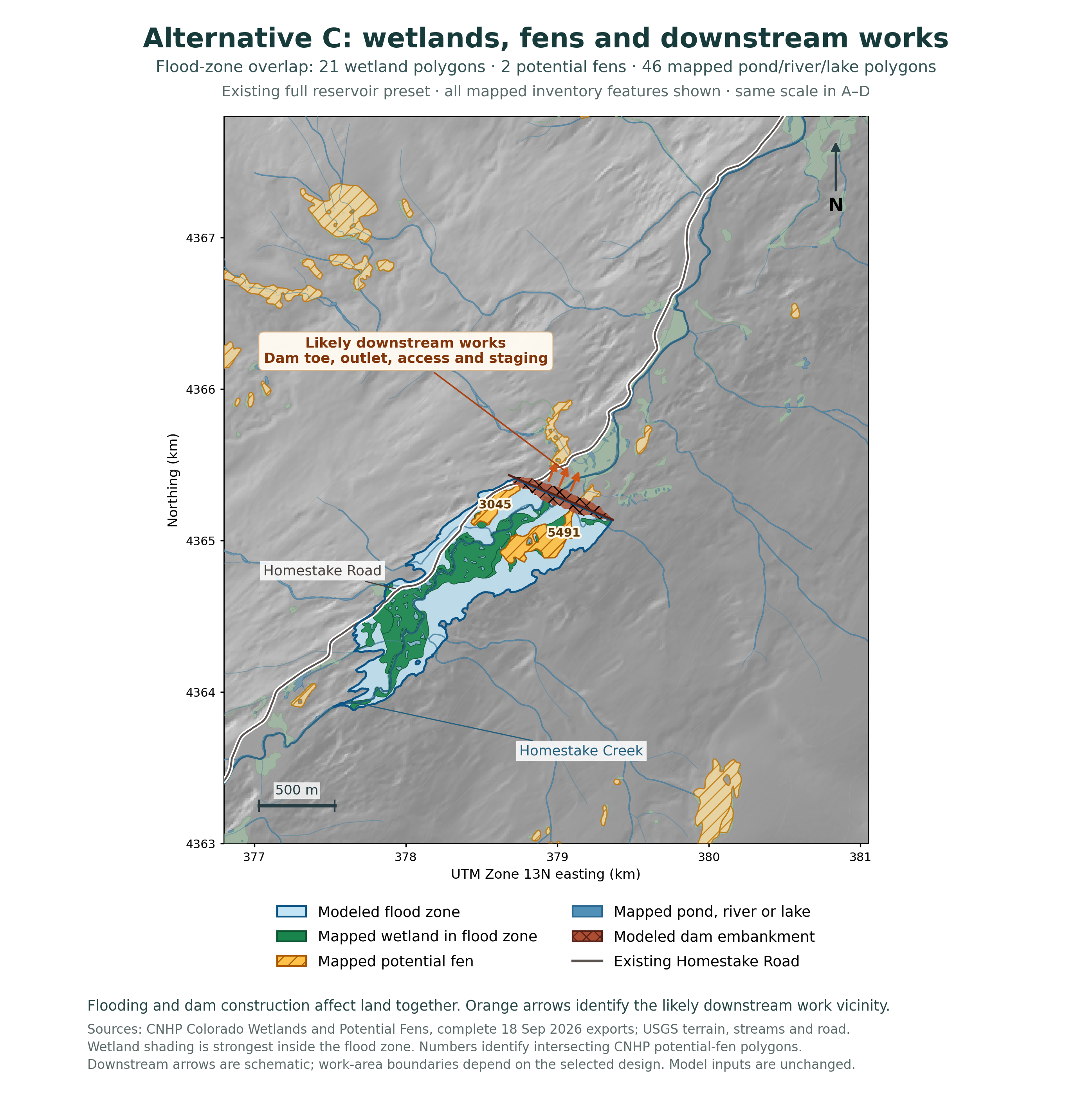
Evidence: S09 · S11 · S26 · S30. Full titles and pinpoints in the evidence register.
Modeled flood zone and downstream construction
Alternative D: wetlands and works
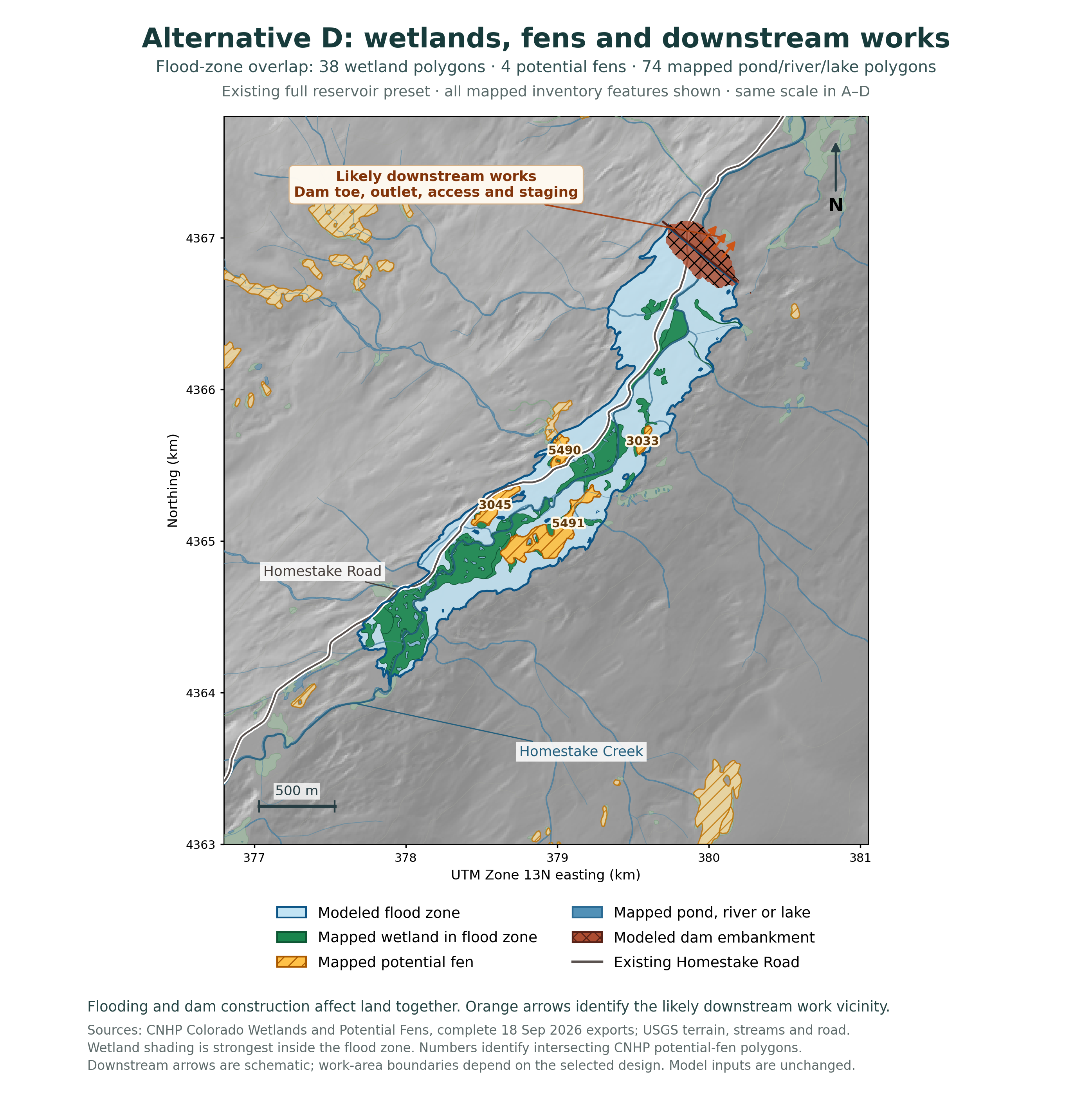
Evidence: S09 · S11 · S26 · S30. Full titles and pinpoints in the evidence register.
CRITERION RECORD · EVIDENCE
Wetlands and fens
1 / Resource or issue
Wetlands and fens within the complete construction and operating impact area.
2 / What the governing code requires
§6.04.01(17): “The Project will not significantly degrade wetlands, and riparian areas.” [S01, PDF p.19].
Appendix A directs attention to structure and function, pollutant uptake, extent, species characteristics and diversity, and floodplain function.
September 15 proposed comparison
Section 406(C)(3) prohibits significant deterioration of wetlands and riparian areas in the Impact Area. Its express factors include structure and function, filtering and nutrient uptake, extent and vegetation change. Section 307(F) specifically requires a fen assessment; §406(A) requires compliance with the §307 plans.
3 / What the evidence shows
The full inventory overlay shows wetland and potential-fen habitat in every modeled flood zone, including shared portions of potential-fen polygons 3045 and 5491. Campaign photographs and films document the living fen complex. Permanent inundation would replace peat-forming vegetation and groundwater-fed habitat with reservoir habitat. Federal wetland guidelines recognize permanent flooding as a mechanism of habitat destruction (S28).
EPA describes fens as groundwater-fed peat systems whose natural formation can take up to 10,000 years. Federal mitigation regulations expressly identify fens as difficult to replace. The protected value includes the functioning peat, water regime and biological community accumulated here over time.
A construction condition cannot preserve a fen beneath the modeled reservoir. Any compensation proposal must therefore be tested against the full functional loss and its duration, including failure risk. Counting replacement acres or surviving transplanted plants is not a functional equivalence analysis.
Evidence: S01 · S02 · S10 · S11 · S12 · S13 · S14 · S26 · S27 · S28 · S30. Full titles and pinpoints in the evidence register.
CRITERION RECORD · ANALYSIS + POSITION
Wetlands and fens: the decision
4 / What remains to be resolved
Seasonal wetland/fen delineation, groundwater dependence, peat profiles, functional assessment and the actual mitigation proposal.
5 / Why it matters to this approval standard
The standard protects wetland structure and function. Permanent inundation and interrupted groundwater change the living resource the criterion addresses. Replacement performance and the duration of lost function belong in the compliance finding.
6 / Save Homestake’s position
7 / What the Board must determine
Will the complete project significantly degrade wetland or riparian function after enforceable conditions?
8 / Evidence
Direct source links appear below. Original code, applicant and ecological exhibits are reproduced at the end of this dossier; the source register retains document pinpoints.
Evidence: S01 · S02 · S10 · S11 · S12 · S13 · S14 · S26 · S27 · S28 · S30. Full titles and pinpoints in the evidence register.
CRITERION RECORD · EVIDENCE
Groundwater and peat water supply
1 / Resource or issue
Groundwater and peat water supply within the complete construction and operating impact area.
2 / What the governing code requires
§6.04.01(16): “The Project will not significantly degrade groundwater quality.” [S01, PDF p.19].
Section 6.04.01(16) protects groundwater quality. Appendix A expressly includes aquifer recharge rates, groundwater levels, aquifer capacity, aquifer-stream interfaces and well function. Apply this with the wetland standard in (17) and the soil/geology standard in (20).
September 15 proposed comparison
Section 406(C)(2) expressly covers recharge, groundwater levels and aquifer capacity, and protects the capacity, function and quality of wells. Section 406(C)(3) protects wetland function. The §307 assessment extends to peripheral and downstream surface and subsurface resources.
3 / What the evidence shows
Fens depend on sustained groundwater delivery and chemistry. The utility’s project description includes water collection and pumping to existing Homestake Reservoir. The complete analysis must include dam foundations, trenches, pipelines, access works and any dewatering, as well as the inundation area. These works can intercept groundwater or change its connection to the creek and peat.
The flood maps identify direct inundation; the dam and downstream-work callouts identify additional construction exposure. Excavation, trenches and dewatering can interrupt the groundwater that sustains adjoining peatland, extending harm beyond the visible reservoir edge (S27, printed pp. 16 and 32).
Evidence: S01 · S02 · S08 · S09 · S12. Full titles and pinpoints in the evidence register.
CRITERION RECORD · ANALYSIS + POSITION
Groundwater and peat water supply: the decision
4 / What remains to be resolved
The applicant’s seasonal water levels, gradients, chemistry, dewatering assumptions and connected surface/subsurface model.
5 / Why it matters to this approval standard
Groundwater sustains the peat, vegetation and creek relationships under review. The impact assessment must connect each predicted water change to the protected resource and the relevant groundwater, wetland or soil criterion.
6 / Save Homestake’s position
7 / What the Board must determine
Which groundwater-quality and connected wetland changes remain under the selected design and operating plan?
Require seasonal water levels and gradients, groundwater chemistry, peat and substrate profiles, surface/subsurface connections, construction dewatering assumptions, with-project and no-project simulations, and monitoring thresholds. Identify the responsible party and corrective action before damage occurs. Under the draft, compliance with the watershed plans is itself required by §406(A).
8 / Evidence
Direct source links appear below. Original code, applicant and ecological exhibits are reproduced at the end of this dossier; the source register retains document pinpoints.
Evidence: S01 · S02 · S08 · S09 · S12. Full titles and pinpoints in the evidence register.
Whitney and Blodgett reaches toward Red Cliff
Downstream wetlands at risk
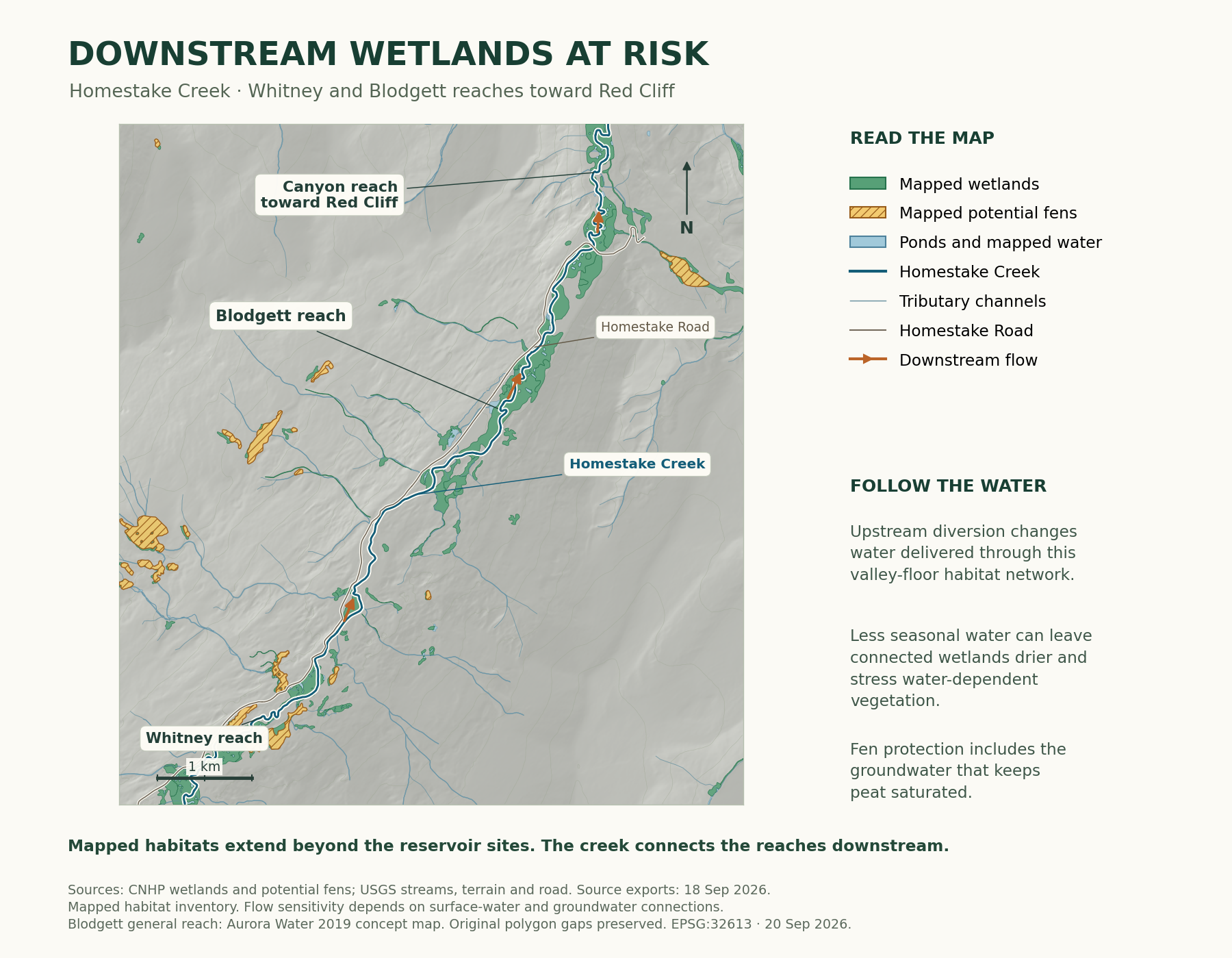
Follow Homestake Creek beyond the proposed dam: a broad wetland landscape continues through the Blodgett reach and lower valley toward the canyon near Red Cliff. Its water connections belong in the project impact area.
Mapped wetland, water and potential-fen categories remain distinct. Evaluate seasonal flow and groundwater changes across this reach, including habitat outside the reservoir flood zones.
Evidence: S26 · S30 · S34. Full titles and pinpoints in the evidence register.
Downstream wetlands and the case for denial
Downstream water supports connected habitat
Reduced flows can lower shallow water tables and shorten the periods when the creek replenishes connected wetlands and side channels. That can leave wetland soils drier, stress willows and other water-dependent vegetation, and shrink the wet habitat that supports wildlife. The timing matters: capturing spring runoff and reducing water during dry periods can harm different parts of the same system.
Fens depend on sustained groundwater that keeps their peat saturated. Where altered creek levels or construction disrupt that supply, wetland plants can change and exposed peat can decompose, releasing stored carbon. Protecting a fen means protecting the water that keeps it alive, including the connections outside its mapped boundary.
Current and proposed protections
Current §§6.04.01(15)-(18) protect surface water, groundwater, wetlands and aquatic habitat; Appendix A includes aquifer-stream relationships and flow-dependent habitat. If effective in its September 15 form, proposed §§307 and 406 expressly require assessment of downstream surface and subsurface resources and protect these functions.
Require matched with-project and no-project seasonal flows, wetland water levels, peat saturation and habitat assessments, including existing withdrawals, spring capture, summer low flows and consecutive dry years. Identify the flow and groundwater connections of each affected wetland.
Evidence: S01 · S02 · S27 · S32 · S33 · S34. Full titles and pinpoints in the evidence register.
CRITERION RECORD · EVIDENCE
Surface water and aquatic habitat
1 / Resource or issue
Surface water and aquatic habitat within the complete construction and operating impact area.
2 / What the governing code requires
§6.04.01(15): “The Project will not significantly degrade surface water quality.” [S01, PDF p.19].
Sections 6.04.01(15) and (18) protect surface-water quality and aquatic life/habitat. Appendix A specifically identifies flushing flows, mine-waste dilution, temperature, sediment, spawning habitat and aquatic food webs.
September 15 proposed comparison
Section 406(C)(1) protects flows, hydrology and water quality, including a requirement that pollutant concentrations not increase over baseline. Section 406(C)(4) protects aquatic life and habitat, including off-channel habitat, oxygen, flushing flows and spawning/egg-to-fry survival. Section 408 requires consistency with the identified water-quality and stream-management plans.
3 / What the evidence shows
Appendix K of the Community Water Plan models a mean May zinc-load reduction requirement of 140.6 kilograms at baseline versus 434.3 kilograms under New Water Infrastructure with historical hydrology. The corresponding additional dilution volume rises from 495.5 to 1,530.3 acre-feet. These are about 3.1 times baseline, holding historical metal loading fixed.
This combined scenario includes 2050 demand growth, a potential MOU infrastructure/operations pathway and Bolts Lake. The May values measure relative ecological risk and mitigation burden under changed flows; they are not additional zinc discharges, annual totals or a regulatory violation finding. The numerical exhibit gives the exact source rows and method.
Evaluate spring capture and seasonal releases separately. Tie enforceable flow and quality commitments to the affected reaches, dry-year conditions and thresholds. An average annual water balance cannot explain a seasonal water-quality failure.
Evidence: S01 · S02 · S15 · S17 · S18. Full titles and pinpoints in the evidence register.
CRITERION RECORD · ANALYSIS + POSITION
Surface water and aquatic habitat: the decision
4 / What remains to be resolved
Whitney-specific matched hydrographs, temperatures, concentrations, release commitments and aquatic responses.
5 / Why it matters to this approval standard
Flow timing affects dilution, temperature and habitat. A matched project/no-project analysis connects the proposed operation to the surface-water and aquatic-life standards.
6 / Save Homestake’s position
7 / What the Board must determine
Would incremental quality or habitat effects remain significant under the actual operating conditions?
8 / Evidence
Direct source links appear below. Original code, applicant and ecological exhibits are reproduced at the end of this dossier; the source register retains document pinpoints.
Evidence: S01 · S02 · S15 · S17 · S18. Full titles and pinpoints in the evidence register.
Original appendices checked September 20, 2026
Verified river-impact evidence
Whitewater opportunities • Appendix N §6, p. 22
| Reach | Dry years | Wet years |
|---|---|---|
| Tigiwon to Dowd Junction | 85% fewer days | 48% fewer days |
| Edwards to Eagle | 9% fewer days | 10% fewer days |
Published total whitewater boatable-day reductions: New Water Infrastructure with historical hydrology versus Baseline. The metric combines kayaking and rafting flow preferences. These percentages are the original analysts’ reported results, not independently rerun simulations.
Zinc • Appendix K Tables 12-13, pp. 21-22
| Mean May metric | Baseline | NWI-H |
|---|---|---|
| Load reduction to chronic rainbow-trout threshold | 140.6 kg | 434.3 kg |
| Additional discharge dilution gap | 495.5 acre-feet | 1,530.3 acre-feet |
Mean monthly totals for the 2009-2016 assessment, holding historical loading patterns fixed while varying flow. The source narrative p. 9 rounds these to 140→434 kg and 496→1,530 acre-feet. Both comparisons are about 3.1 times baseline. Quantitative climate-change projections were excluded from this metals calculation.
The scenario boundary • Appendix C pp. 9-11
The baseline represents the plan’s 2020 current conditions. NWI-H combines projected 2050 demand growth, one potential MOU infrastructure/operations pathway, and Bolts Lake redevelopment under historical hydrology. These are combined-development results. A Whitney permit record must quantify Whitney’s incremental effects using matched assumptions.
Evidence: S15 · S16 · S17. Full titles and pinpoints in the evidence register.
CRITERION RECORD · EVIDENCE
Wildlife and habitat connectivity
1 / Resource or issue
Wildlife and habitat connectivity within the complete construction and operating impact area.
2 / What the governing code requires
§6.04.01(18): “The Project will not significantly degrade terrestrial or aquatic animal life or its habitats.” [S01, PDF p.19].
Section 6.04.01(18) prohibits significant degradation of terrestrial or aquatic animal life or habitat. Appendix A names migration routes, seasonal range, calving, mating and nesting areas, threatened/endangered species, habitat features and food webs.
September 15 proposed comparison
Section 411 prohibits significant deterioration of wildlife or habitat in the Impact Area and requires CPW consultation documentation. Section 310 requires baseline, impact, mitigation and monitoring information, including corridors and seasonal habitat. Aquatic protection also appears in §406(C)(4).
3 / What the evidence shows
The 2019 applicant report identifies deer/elk winter range and potential sensitive-species habitat (Technical Report pp. 17-19). The campaign’s Valley Floor 1 archive documents repeated moose use of a creek-parallel route across seasons. Public photographs and films record wildlife in the wetland/forest mosaic at risk. Locations are generalized.
Save Homestake reports firsthand encounters with as many as four boreal toads in a single viewing. The assessment that this is uncommon comes from personal experience and Team Toad volunteering. These observations add a human field record of the wetland habitat at risk.
Reservoir inundation removes the existing terrestrial/wetland habitat. Roads, clearing, traffic, lighting and operation can add barriers and disturbance beyond the waterline. Habitat connectivity is itself a protected function.
Evidence: S01 · S02 · S10 · S11 · S09. Full titles and pinpoints in the evidence register.
CRITERION RECORD · ANALYSIS + POSITION
Wildlife and habitat connectivity: the decision
4 / What remains to be resolved
Current breeding/recruitment, habitat and movement surveys; complete facility footprint and offered mitigation.
5 / Why it matters to this approval standard
A connected habitat supplies breeding sites, movement routes and seasonal resources. The criterion reaches those functions as well as observed animals.
6 / Save Homestake’s position
7 / What the Board must determine
Which protected habitat functions would be lost, fragmented or significantly degraded, and what remains after mitigation?
Submit dated observations, habitat overlays and seasonal-use evidence. CPW consultation contributes expertise; the Board still must make the substantive compliance finding. Protect sensitive species locations in the public record.
8 / Evidence
Direct source links appear below. Original code, applicant and ecological exhibits are reproduced at the end of this dossier; the source register retains document pinpoints.
Evidence: S01 · S02 · S10 · S11 · S09. Full titles and pinpoints in the evidence register.
FIELD RECORDS + SCREENED OCCURRENCES
A growing local biological record
- BioBlitz record in the reviewed v0.3 package · OBSERVATIONS
- 1,400
- Within 229 terminal taxonomic concepts · SPECIES-RANK CONCEPTS
- 190
Quality grades: 618 Research Grade, 778 Needs ID and four Casual. These sum to the 1,400 observations. Taxonomic concepts and occurrence records measure different things; neither number is interchangeable with a count of verified species within a reservoir footprint.
Additional retained records
The package retains 233 screened GBIF/locality records, including 129 eBird-derived occurrences and 103 specimen records. These are additional source records with their own locality, age and precision; the record retains their attribution and screening decisions.
Historical upper-Homestake evidence
CNHP’s 2000 survey documents boreal-toad breeding and Colorado River cutthroat trout in upper Homestake tributaries (printed p.159 / PDF p.162). CPW’s 2006-2007 monitoring adds pond drying and recruitment uncertainty (printed p.36). These are historical, geographically identified records that guide present-day breeding, recruitment and fish-genetics work.
A corrected moose claim
Abouelezz and Hobbs studied 21 adult moose and 1,672 summer GPS locations in and near Rocky Mountain National Park during 2017-2018. About 90% were within approximately 285 m of mapped flowing or standing water; the mean was approximately 110 m. This is regional ecological evidence from that population, season and method. It replaces the unsupported universal half-mile assertion.
Evidence: HWF:REGISTRY · HWF:V3-17 · HWF:V3-24 · HWF:V3-01. Full titles and pinpoints in the evidence register.
GOVERNMENT RECORD + FIELD RECORD
Lynx: status, habitat and local record
The Canada lynx in the contiguous United States is federally threatened and is listed as endangered by Colorado. A final federal critical-habitat revision became effective August 17, 2026. Its Southern Rockies Unit 6 includes designated areas in Colorado, including portions of Eagle County.
Final rule and geography
The rule was published July 16, 2026 at 91 FR 43732, with an August 17 effective date. Unit 6 geography appears at printed p.43771 / PDF p.40; the regional map follows on p.43772 / PDF p.41. The governing boundaries include textual exclusions as well as mapped designation.
The separate local record
Save Homestake’s 2017 down-valley camera image near Blodgett is a field record with its own date and location. The final regional designation, a local observation and the exposure of a particular project alternative are separate records to connect.
The decision-relevant next record
Obtain the final authoritative designation polygons and apply the textual exclusions to each actual reservoir, road, power and conveyance alternative. Pair that overlay with appropriate current occupancy and seasonal habitat evidence under §6.04.01(18).
Why it matters: habitat protection depends on the resource and function present, while final designation and local observations help identify the surveys, consultation and connected habitat questions the complete project must address.
Evidence: HWF:S22 · HWF:S39 · FED-ECFR-17.11-LYNX · S10 · S01. Full titles and pinpoints in the evidence register.
Ecology exhibit · September 23, 2026
The connected wetland mosaic
CNHP's 2000 Eagle County survey documents boreal-toad breeding and a Colorado River cutthroat trout population in the upper Homestake tributaries. These historical records give amphibian breeding habitat and cold-water streams a documented place in the valley's conservation case. Current surveys should establish breeding, recruitment, fish genetics and seasonal water needs at the resources exposed to each project alternative.
Historical source: CNHP 2000, printed p.159 / PDF p.162 (HWF:V3-C003/004). CPW 2006-2007 monitoring, printed p.36, adds a record of pond drying and recruitment uncertainty. Keep the upper-tributary geography and historical period attached to these findings.
Homestake's fens, wet meadows, willow corridors, beaver ponds and streams sustain different parts of a living valley. The water connecting them matters through spring runoff, summer low flows and drought. Colorado field studies document changes to streamside vegetation below diversions and lasting damage to drained peat. Protecting Homestake means protecting the seasonal water and connected habitats that keep it alive.
A resource and function record
- Inventory each resource with survey date, extent, identification grade and positional precision. Use generalized public locations.
- Evaluate all permanent and temporary works: roads, pumping, power, tunnels/pipes, access, inundation and drawdown.
- Link measured water dependency to alternative-specific exposure, biological consequences and the applicable finding.
Evidence: HWF:V3-17 · HWF:V3-24 · S01 · S02. Full titles and pinpoints in the evidence register.
Ecology exhibit · September 23, 2026
Measured functions the review must address
Colorado: channels, peat and beaver water
HWF:V3-ST02, Caskey et al.: 37 north-central Colorado reaches, including 16 pairs. Diversion reaches had smaller channel dimensions and vegetation shifts toward drier-site species (Methods; Table IV; pp.592-594).
HWF:V3-ST04, Schimelpfenig et al.: four restored Colorado fens. Summer water tables rose after ditch blocking, while disturbed surface peat still differed from reference peat at the site restored 20 years earlier (abstract, Table 1 and Results).
HWF:V3-ST03, Westbrook et al.: monitoring two dams in Rocky Mountain National Park found slower seasonal groundwater decline over 9 and 12 hectares, respectively. These are measured study areas, not additive or transferable buffers (USGS abstract).
Wildlife and food
HWF:V3-ST01, Abouelezz and Hobbs: 21 adults, 1,672 summer GPS locations in and near Rocky Mountain National Park, 2017-2018. About 90% were within 285 metres of mapped flowing or standing water (Methods; Table 1).
HWF:V3-ST11, Rhoades et al.: upper Shasta River, California, wet 2019. Late-season drifting prey approached zero below one diversion while streambed biomass could be higher. Measure prey delivery as well as standing stock (Methods; Results; Discussion).
Evidence: HWF:S31 · HWF:V3-07 · HWF:S12 · HWF:V3-01 · HWF:V3-21. Full titles and pinpoints in the evidence register.
Ecology exhibit · September 23, 2026
Water and wetland criteria
Published current Chapter VI; §6.04.01 and Appendix A pp.iv-vi. Appendix A guides evaluation and is not a separate set of approval criteria.
§6.04.01(15) · Surface water
Daily current, no-action and project hydrographs at matched reaches; temperature, dissolved oxygen, sediment and flushing flows.
Finding: Magnitude, timing and duration of additional water-quality and channel change. Evidence: HWF:V3-ST02, HWF:V3-ST11, HWF:V3-C011.
§6.04.01(16) · Groundwater
Nested wells, creek/pond-stage correlations, recharge models and groundwater predictions for each potentially affected fen and meadow.
Finding: Which sites depend on the changed source, with the size and duration of water-level changes. Evidence: HWF:V3-ST03, HWF:V3-ST04, HWF:V3-PW01, HWF:V3-PW05.
§6.04.01(17) · Wetlands and riparian areas
Peat, hydroperiod, vegetation, water filtration and floodplain baseline; all permanent and temporary works and drawdown scenarios.
Finding: Direct and indirect functional loss, avoidance and duration of any replacement deficit. Evidence: HWF:V3-ST02, HWF:V3-ST03, HWF:V3-ST04, HWF:V3-ST05.
September 15 proposed crosswalk: Surface water §406(C)(1); Groundwater §§307(F), 406(C)(2); Wetlands and riparian areas §§307(F), 406(C)(3). Apply only if adopted, effective and applicable; check final numbering and transition provisions.
Evidence: S01 · S02 · HWF:S31 · HWF:V3-21 · HWF:V3-42 · HWF:S12 · HWF:V3-07 · HWF:S28 · HWF:S03 · HWF:V3-02 · HWF:V3-06. Full titles and pinpoints in the evidence register.
Ecology exhibit · September 23, 2026
Habitat, plants and soils criteria
Published current Chapter VI; §6.04.01 and Appendix A pp.iv-vi. Appendix A guides evaluation and is not a separate set of approval criteria.
§6.04.01(18) · Animals and habitat
Breeding/recruitment surveys, fish genetics, movement, prey production and transport, and final critical-habitat GIS against actual alternatives.
Finding: Exposure and effects on the documented habitat, breeding, connectivity and food-web functions. Evidence: HWF:V3-C003, HWF:V3-C004, HWF:V3-ST06, HWF:V3-ST08, HWF:V3-ST11.
§6.04.01(19) · Plants and habitat
Specialist identifications and complete community plots paired with peat, hydrology and an invasive-plant baseline.
Finding: Affected communities and expected composition, structure and productivity changes. Evidence: HWF:V3-C007, HWF:V3-ST02, HWF:V3-ST05.
§6.04.01(20) · Soils and geology
Peat stratigraphy, drainage and erosion assessment; measurable restoration performance and recovery time.
Finding: Residual peat/soil loss and the credibility of replacement performance. Evidence: HWF:V3-ST04, HWF:V3-PW01.
September 15 proposed crosswalk: Animals and habitat §§307(G), 310, 406(C)(4), 411; Plants and habitat §§311, 412; Soils and geology §413. Apply only if adopted, effective and applicable; check final numbering and transition provisions.
Evidence: S01 · S02 · HWF:V3-17 · HWF:V3-24 · HWF:V3-04 · HWF:V3-05 · HWF:S11 · HWF:S34 · HWF:V3-18 · HWF:V3-21 · HWF:V3-34 · HWF:S31 · HWF:V3-06 · HWF:V3-07 · HWF:S28 · HWF:S03. Full titles and pinpoints in the evidence register.
CRITERION RECORD · EVIDENCE
Plants, peat and soils
1 / Resource or issue
Plants, peat and soils within the complete construction and operating impact area.
2 / What the governing code requires
§6.04.01(19): “The Project will not significantly deteriorate terrestrial plant life or plant habitat.” [S01, PDF p.19]. Read (19) with (20): “The Project will not significantly deteriorate soils and geologic conditions.”
Section 6.04.01(19) protects terrestrial plant life and habitat from significant deterioration. Appendix A includes vegetation structure, function, species composition, diversity, biomass and productivity. Section (20) separately protects soils and geologic conditions.
September 15 proposed comparison
Section 412 protects terrestrial plant communities. Sections 311 and 413 address vegetation evidence and soil/geologic protection; §432 governs revegetation and invasive species. Fen vegetation also falls within the watershed and wetland analysis.
3 / What the evidence shows
The applicant’s 2019 report describes forest, meadows and wetlands (p. 21). Campaign photographs and modeling show conversion of living fen vegetation to open water and reservoir shore. Its peat-forming plants, substrate and groundwater regime function together; flooding changes that system even if plants grow elsewhere.
The 1994 Homestake II decision records competent evidence of predicted wetland degradation and ineffective mitigation threatening rare moss in that earlier project. It demonstrates the legal importance of specific botanical evidence. Whitney’s findings should identify the plant communities and functions documented within its own impact area.
Evidence: S01 · S02 · S07 · S10 · S11 · S12 · S09. Full titles and pinpoints in the evidence register.
CRITERION RECORD · ANALYSIS + POSITION
Plants, peat and soils: the decision
4 / What remains to be resolved
Botanical community plots, peat and soil profiles, complete impact footprint and demonstrated recovery functions.
5 / Why it matters to this approval standard
Plant composition, peat structure and hydrologic support operate together. The protected resource includes the existing community and the time needed to recover its function.
6 / Save Homestake’s position
7 / What the Board must determine
Would plant habitat or peat/soil condition significantly deteriorate after enforceable conditions?
Require seasonal botanical inventory, mapped vegetation communities, peat and soil characterization, hydrologic requirements, and separate evaluation of construction disturbance and permanent inundation. A revegetation plan for temporarily disturbed ground addresses a different impact from permanent conversion beneath a reservoir.
8 / Evidence
Direct source links appear below. Original code, applicant and ecological exhibits are reproduced at the end of this dossier; the source register retains document pinpoints.
Evidence: S01 · S02 · S07 · S10 · S11 · S12 · S09. Full titles and pinpoints in the evidence register.
CRITERION RECORD · EVIDENCE
Recreation and public experience
1 / Resource or issue
Recreation and public experience within the complete construction and operating impact area.
2 / What the governing code requires
§6.04.01(11): “The Project will not have a significant adverse effect on the quality or quantity of recreational opportunities and experience.” [S01, PDF p.19].
Section 6.04.01(11) protects the quality and quantity of recreational opportunities and experience. Appendix A names visitor days, rafting/kayaking seasons, fisheries, flows and reservoir levels, access, trails, wilderness experience and solitude.
September 15 proposed comparison
Section 423 retains a significant-degradation standard for opportunities and experience in the Impact Area. Section 321 requires recreation assessment, including access, boating, fishing seasons and heat closures, trails and wilderness experience.
3 / What the evidence shows
The applicant’s 2019 report identifies FR703 access to Gold Park Campground, Holy Cross Wilderness trailheads and Homestake Reservoir, and camping, hiking, fishing, boating and wildlife viewing (p. 22). Campaign photographs and modeling depict the existing landscape and its conversion. Assess displaced uses, access closures, noise and operating water levels.
Appendix N reports 85% fewer whitewater boatable days in dry years and 48% fewer in wet years on the Tigiwon-to-Dowd reach in the combined New Water Infrastructure historical-hydrology scenario. Edwards-to-Eagle losses are 9% and 10%. These are modeled flow opportunities for kayaking and rafting, not measured Whitney-only losses.
Require a mapped inventory of access, trails, campsites and use areas; affected seasons and closure durations; flows and operating water levels; and user testimony. Evaluate any proposed reservoir recreation on its actual access, safety, season and operating conditions. Tie the decision to current §6.04.01(11), or draft §423 if effective.
Evidence: S01 · S02 · S10 · S11 · S15 · S16 · S09. Full titles and pinpoints in the evidence register.
CRITERION RECORD · ANALYSIS + POSITION
Recreation and public experience: the decision
4 / What remains to be resolved
Applicant’s access and closure schedule, operational water levels, existing-use record and recreational effects.
5 / Why it matters to this approval standard
The code protects the experience people already have here, including access, season, scenery and quiet. The Board must evaluate changes to that existing experience.
6 / Save Homestake’s position
7 / What the Board must determine
Would the quality or quantity of existing recreation significantly decline after proposed measures?
8 / Evidence
Direct source links appear below. Original code, applicant and ecological exhibits are reproduced at the end of this dossier; the source register retains document pinpoints.
Evidence: S01 · S02 · S10 · S11 · S15 · S16 · S09. Full titles and pinpoints in the evidence register.
CRITERION RECORD · EVIDENCE
Noise, roads, power and maintenance
1 / Resource or issue
Whitney would bring an operating system into a landscape valued for quiet, wildlife and public recreation. Pumps, electrical equipment, access roads and conveyance facilities need recurring service. Noise, traffic, light and repair activity belong in the permit decision throughout the project’s life.
2 / What the governing code requires
§6.04.01(21): “The Project will not cause a nuisance.” [S01, PDF p.19].
Section 6.04.01(21) prohibits a nuisance. Appendix A identifies dust, fumes, glare, heat, noise, vibration, artificial light and traffic. Recreation and visual criteria, (11) and (14), separately protect public experience and scenery.
September 15 proposed comparison
Section 429 protects use and enjoyment of property in the Impact Area and existing owners from nuisance. Sections 425-426 address traffic and road costs; §§430, 410, 423 and 431 address dust, air, recreation and scenery. Section 327 requires construction and operation nuisance assessment.
3 / What the evidence shows
CSU describes pumping and conveyance (S08, p. 1; S29). Construction introduces equipment, haul traffic, excavation and work areas. During operation, pumps and associated equipment can produce recurring noise and vibration; inspections and repairs add service traffic and renewed work. The field archive documents the present landscape and use (S10).
The Homestake II decision records evidence of noise, dust and tunnel-work effects on recreation and scenery that supported denial of that earlier design (S07). For Whitney, the component tables identify the sources and phases to evaluate against the valley’s existing quiet and uses.
Evidence: S01 · S02 · S07 · S08 · S10 · S29. Full titles and pinpoints in the evidence register.
CRITERION RECORD · ANALYSIS + POSITION
Noise, roads, power and maintenance: the decision
4 / What remains to be resolved
Applicant’s equipment, receptor, noise, vibration, traffic, lighting and maintenance assessments for construction and operation.
5 / Why it matters to this approval standard
Recurring operation and maintenance can affect the same quiet, access and enjoyment exposed during construction. The nuisance test applies to the actual disturbance left after controls.
6 / Save Homestake’s position
7 / What the Board must determine
Will construction or continued operation cause a nuisance after the proposed controls?
The finding should identify the affected uses, sound and vibration characteristics, timing, lighting, haul/service traffic, closures and maintenance schedule. Assess equipment enclosures, hours and other controls against the actual disturbance that remains.
8 / Evidence
Direct source links appear below. Original code, applicant and ecological exhibits are reproduced at the end of this dossier; the source register retains document pinpoints.
Evidence: S01 · S02 · S07 · S08 · S10 · S29. Full titles and pinpoints in the evidence register.
CRITERION RECORD · EVIDENCE
Landscape, cultural and historic resources
1 / Resource or issue
Landscape, cultural and historic resources within the complete construction and operating impact area.
2 / What the governing code requires
§6.04.01(14); §6.04.01(22): “The Project will not significantly degrade existing visual quality. / The Project will not significantly degrade areas of paleontological, historic, or archaeological importance.” [S01, PDF p.19].
Current §6.04.01(14) protects existing visual quality; (22) protects areas of paleontological, historic or archaeological importance. Draft §431 protects visual quality in the Impact Area; §424 protects the identified cultural-resource areas. Sections 322 and 329 require the associated evidence.
3 / What the evidence shows
The field views and reservoir model show conversion of the creek, fen and forest setting. Add the visible dam, pump buildings, cleared access, portals and selected electrical works to that view. Full-pool, normal-operation and low-water views should show the complete operating landscape and its effects on existing scenery.
The Camp Hale-Continental Divide proclamation recognizes Ute relationships and military history in this mountain landscape. These connections give the cultural review its human importance. Whitney’s mapped footprint and associated works must be surveyed for the actual historic, archaeological and cultural resources affected, with meaningful Tribal participation and protected confidential locations.
Flooding, excavation, blasting or road relocation can destroy physical evidence and alter a resource’s setting. Require the relevant surveys, eligibility and significance determinations, effect analysis, consultation record and avoidance/treatment commitments for all facilities.
Evidence: S01 · S02 · S08 · S10 · S11 · S21. Full titles and pinpoints in the evidence register.
CRITERION RECORD · ANALYSIS + POSITION
Landscape, cultural and historic resources: the decision
4 / What remains to be resolved
All-facility viewsheds and operating levels; professional inventories, significance findings and meaningful Tribal participation.
5 / Why it matters to this approval standard
Scenic character and documented historic or archaeological importance are separate protected interests. Each finding should identify the affected resource, project effect and remaining harm.
6 / Save Homestake’s position
7 / What the Board must determine
Will documented scenery or important historic/archaeological areas suffer significant degradation after treatment?
8 / Evidence
Direct source links appear below. Original code, applicant and ecological exhibits are reproduced at the end of this dossier; the source register retains document pinpoints.
Evidence: S01 · S02 · S08 · S10 · S11 · S21. Full titles and pinpoints in the evidence register.
CRITERION RECORD · EVIDENCE
Demonstrated necessity
1 / Resource or issue
Demonstrated necessity within the complete construction and operating impact area.
2 / What the governing code requires
§6.04.02(3): “The Project shall be necessary to meet community development and population demands in the areas to be served by the Project.” [S01, PDF p.20].
Appendix A identifies reasonable growth projections, local land-use plans and relationships to other providers’ service areas.
September 15 proposed comparison
The draft has no equivalent standalone Article 4 necessity test. Sections 303(D) and 331(B) still require need, demand and projection information. That information also matters to feasibility, dependable supply and efficient use, but the omitted necessity criterion cannot be treated as if it remains in Article 4.
3 / What the evidence shows
The March 2022 utility fact sheet presents Whitney as part of a larger supply program and describes a range of potential storage capacities. A program target and a storage volume do not quantify the specific service-area demand Whitney must meet after existing investments, conservation and reuse.
The current criterion lets the County require a demonstrated relationship between the proposed sacrifice and a reasonable, documented need. Service-area forecasts, demand management and dependable delivery belong in the same comparison.
Evidence: S01 · S02 · S08. Full titles and pinpoints in the evidence register.
CRITERION RECORD · ANALYSIS + POSITION
Demonstrated necessity: the decision
4 / What remains to be resolved
Current service-area demand, reasonable growth, existing/committed supplies, Whitney-only dependable yield and alternatives.
5 / Why it matters to this approval standard
Necessity depends on actual demand, committed supplies and dependable additional delivery. A common reliability basis makes the comparison with demand management and alternatives useful.
6 / Save Homestake’s position
7 / What the Board must determine
Has the applicant demonstrated necessity under a defensible service-area demand and supply record?
Require measured demand, reasonable growth forecasts, committed supplies, adopted projects, emergency-reserve objectives, conservation and reuse assumptions, and a common reliability standard. Compare a no-Whitney portfolio under the same assumptions. The current application’s alternatives requirements provide the record for this assessment.
Before adoption, restore necessity as an explicit approval standard. If the draft takes effect unchanged, direct the same demand evidence to the standards it actually retains rather than claiming the former test still governs.
8 / Evidence
Direct source links appear below. Original code, applicant and ecological exhibits are reproduced at the end of this dossier; the source register retains document pinpoints.
Evidence: S01 · S02 · S08. Full titles and pinpoints in the evidence register.
CRITERION RECORD · EVIDENCE
Efficient use, conservation and reuse
1 / Resource or issue
Efficient use, conservation and reuse within the complete construction and operating impact area.
2 / What the governing code requires
§6.04.02(1): “The Project shall emphasize the most efficient use of water, including the recycling, reuse and conservation of water.” [S01, PDF p.20].
Current §6.04.01(12) also addresses resource conservation, energy efficiency and recycling/reuse. Appendix A asks about readily available conservation and recycling to the greatest extent allowed by law.
September 15 proposed comparison
Section 434(D) requires planning, design and operation emphasizing the most efficient use of water, including recycling and reuse. It omits the express word “conservation” found in current §6.04.02(1). Conservation remains expressly required in the §331(A)(3) and §331(E) application materials. The same narrower §434(D) wording appeared in July as §435(D).
3 / What the evidence shows
The proposed system collects and pumps headwater water for additional supply. Demand reduction, lawful reuse and existing-system improvements should be evaluated in dependable acre-feet, timing, cost and environmental effect. The code’s efficiency requirement concerns how the project is actually planned and operated.
Require measured distribution losses, outdoor-demand measures, feasible recycling/reuse, legal limits, seasonal demand, operating losses and the energy implications of pumping. Identify additional savings beyond measures already assumed in the baseline.
Evidence: S01 · S02 · S05 · S08. Full titles and pinpoints in the evidence register.
CRITERION RECORD · ANALYSIS + POSITION
Efficient use, conservation and reuse: the decision
4 / What remains to be resolved
Measured progress and remaining practicable savings, with implementation dates and independently reviewable assumptions.
5 / Why it matters to this approval standard
Measured conservation and reuse affect how much additional source water is needed and how efficiently the project operates. Crediting existing progress establishes the correct baseline for additional potential.
6 / Save Homestake’s position
7 / What the Board must determine
Does the proposed project emphasize the most efficient use of water under the actual planning and operating record?
Conditions must be measurable and enforceable: the measure, implementation date, achieved savings, monitoring, funding and response to failure. A general promise of future efficiency cannot substitute for a compliance finding. Restore express conservation language in the substantive approval standard before adoption.
8 / Evidence
Direct source links appear below. Original code, applicant and ecological exhibits are reproduced at the end of this dossier; the source register retains document pinpoints.
Evidence: S01 · S02 · S05 · S08. Full titles and pinpoints in the evidence register.
UTILITY REPORTS + PLANNING RECORD
Credit the progress. Quantify what remains.
Aurora and Colorado Springs have real supply-planning responsibilities and documented conservation and reuse progress. That progress belongs in the starting baseline for a fair, practical alternatives comparison.
| Progress already reported | Additional practicable potential / record needed |
|---|---|
| Aurora reports a 36% reduction in water use since the early 2000s and a use rate of 115 gallons per person per day. [MUN-S01] | Its stated goal is a further 10% consumption reduction by 2040. Verify the baseline and additionality before converting the goal to annual AF. |
| Aurora’s 2022 ordinance restricts ornamental turf in new development. Prairie Waters supplies up to 10 million gallons daily, according to the mayor. [MUN-S02] | Obtain actual annual reuse deliveries, existing turf by category and additional savings beyond adopted demand assumptions. Capacity is distinct from actual annual production. |
| CSU reports per-capita consumption down 40% since 2001 and 71,960 AF delivered to its potable distribution system in 2024. [MUN-S04] | Its 2025 update cites 7,900 AF of achievable conservation savings through 2070. Obtain the underlying study’s annual schedule and baseline. [MUN-S05] |
| CSU reports 276 AF/year of savings from 2024 conservation work. [MUN-S05] | Compare further implementation measures with Whitney-only dependable annual yield under the same reliability, timing and legal-availability assumptions. |
Outdoor demand is a useful planning category
Aurora’s mayor describes outdoor irrigation as historically about 50% of total annual use; CSU’s 2022 plan estimates irrigation at about 40% of annual potable demand. Those dated scopes identify a demand-management opportunity. Current outdoor AF/year and practicable additional savings require a matched current dataset. [MUN-S02; MUN-S06]
Compare annual savings with annual dependable supply. The 6,850-20,000 AF Whitney storage concepts are a capacity measure, not an annual-yield denominator.
Evidence: MUN-S01 · MUN-S02 · MUN-S04 · MUN-S05 · MUN-S06 · S08. Full titles and pinpoints in the evidence register.
CRITERION RECORD · EVIDENCE
Dependable supply and feasible operation
1 / Resource or issue
Dependable supply and feasible operation within the complete construction and operating impact area.
2 / What the governing code requires
§6.04.01(5): “The Project is technically and financially feasible.” [S01, PDF p.19].
Current §6.04.01(5) requires technical and financial feasibility; §6.04.02(3) requires necessity. Apply the required project, water-supply, cost and operating information to those tests. Section 6.04.01(8) also protects local service capacity; Appendix A expressly considers reductions in water available for future County supply.
September 15 proposed comparison
Section 409 expressly requires adequate supplies for current and future operational needs in quantity, quality and dependability. Section 403 requires technical and financial feasibility, including operation, mitigation and monitoring costs. Section 308 requires sources, legal rights, amounts, diversion changes, existing uses and alternative supplies.
3 / What the evidence shows
The utility’s March 2022 sheet gives Whitney storage concepts ranging from 6,850 to 20,000 acre-feet and describes uphill pumping to existing Homestake Reservoir. Storage capacity, annual deliveries and drought reliability measure different things. The key question is what additional useful water the proposed operation can reliably provide.
Senior rights and governing agreements, refill opportunities, consecutive dry years, evaporation, release commitments, conveyance capacity and power-dependent pumping affect dependable delivery. The same operating model must show reservoir water levels and exposed bed area, which affect scenery, habitat, dust and recreation.
Evidence: S01 · S02 · S08 · S22. Full titles and pinpoints in the evidence register.
CRITERION RECORD · ANALYSIS + POSITION
Dependable supply and feasible operation: the decision
4 / What remains to be resolved
Whitney-only annual/dry-year yield, refill, senior-right constraints, environmental releases, pumping limits and life-cycle costs.
5 / Why it matters to this approval standard
Reliable delivery depends on physical capacity, legal availability, refill and dry-year operation. These conditions connect the supply promise to feasibility and necessity.
6 / Save Homestake’s position
7 / What the Board must determine
Are the proposed system and promised deliveries technically and financially feasible under the governing record?
Require an independently reviewable water balance with matched with-project/no-project runs, dry sequences, senior-right administration, applicable agreements, pumping and conveyance limits, environmental releases, refill time and full lifecycle costs. Explain which promised deliveries remain dependable and which rely on conditions that are not secured.
8 / Evidence
Direct source links appear below. Original code, applicant and ecological exhibits are reproduced at the end of this dossier; the source register retains document pinpoints.
Evidence: S01 · S02 · S08 · S22. Full titles and pinpoints in the evidence register.
CRITERION RECORD · EVIDENCE
County benefits and resource losses
1 / Resource or issue
County benefits and resource losses within the complete construction and operating impact area.
2 / What the governing code requires
§6.04.01(24): “The benefits accruing to the County and its citizens from the Project outweigh the losses of any natural, agricultural, recreational, grazing, commercial or industrial resources within the County, or the losses of opportunities to develop such resources.” [S01, PDF p.20].
Section 6.04.01(24) requires benefits accruing to Eagle County and its citizens to outweigh losses of natural, agricultural, recreational, grazing, commercial or industrial resources, or opportunities to develop them. Section (10) separately protects current and foreseeable local economic sectors; (9) prohibits an undue financial burden on County residents.
September 15 proposed comparison
The draft omits an equivalent standalone benefits-versus-resource-loss test. Section 422 still prohibits significant degradation of any segment of the County economy. Sections 419 and 420 address local government services and undue tax burden, with different wording and scope from current law.
3 / What the evidence shows
The utility fact sheet identifies a broader MOU goal of 20,000 acre-feet of average annual East Slope supply and 10,000 acre-feet of firm dry-year West Slope supply. Those are program goals. The Board needs binding, incremental benefits attributable to Whitney, compared with permanent losses in Homestake.
CROA estimates 2024 Upper and Lower Eagle commercial rafting direct expenditures at a combined $1,513,348 across 9,200 user days. Appendix N documents modeled boating-day reductions under the combined development scenario. Together they identify an existing livelihood pathway exposed to flow changes. They do not yield a Whitney-specific dollar-loss calculation.
Evidence: S01 · S02 · S08 · S16 · S19. Full titles and pinpoints in the evidence register.
CRITERION RECORD · ANALYSIS + POSITION
County benefits and resource losses: the decision
4 / What remains to be resolved
Binding County deliveries and other benefits, recipients, timing and reliability; permanent losses and future opportunities.
5 / Why it matters to this approval standard
The current rule explicitly compares County benefits with County resource and opportunity losses. Reliable commitments, permanence and the distribution of effects make that comparison meaningful.
6 / Save Homestake’s position
7 / What the Board must determine
Do benefits accruing to Eagle County and its citizens outweigh County resource and opportunity losses?
Compare enforceable local deliveries, reliability and fiscal benefits against lost habitat, recreation, access, economic opportunity and ongoing management costs. Account for permanence and who receives the benefits and bears the costs. Request restoration of the standalone County-benefit test before adoption.
8 / Evidence
Direct source links appear below. Original code, applicant and ecological exhibits are reproduced at the end of this dossier; the source register retains document pinpoints.
Evidence: S01 · S02 · S08 · S16 · S19. Full titles and pinpoints in the evidence register.
Rights, boundaries and jurisdiction
Protect the public-land setting
Save Homestake opposes any change to the Holy Cross Wilderness boundary. The valley’s protected setting and public access must be considered across all facilities and routes, including the conveyance system and recurring maintenance.
Property rights and approvals
Current §6.04.01(1) and draft §404 require necessary property rights, permits and approvals before site disturbance, and allow the Board to defer a decision until outstanding approvals are obtained. Overlay each facility and access route on governing ownership, wilderness and other protected boundaries.
A water right authorizes what its decrees provide; the County’s land-use criteria remain an independent approval requirement. Homestake II upheld denial of a particular noncompliant design while recognizing the cities’ underlying water rights (S07).
Connected effects and geographic authority
Draft §109 defines the Impact Area by likely project effects. Including another political subdivision’s territory under that definition requires a Board intergovernmental agreement for cooperative regulation in both jurisdictions. Document the connected river effects and apply the governing jurisdictional provisions.
Evidence: S01 · S02 · S07 · S09 · S21 · S29. Full titles and pinpoints in the evidence register.
Ecology exhibit · September 23, 2026
Priority records and field measurements
Proposed requests and survey work, not submitted. Each measurement resolves a named exposure or approval question.
- P0 · Applicant: complete alternatives, all works and daily operating hydrographs. Resolve exposure for every criterion and PW01-PW07.
- P0 · CNHP / USFS: original fen plots, peat measurements, delineations and service-version correspondence. Resolve wetland, groundwater, plant and soil baselines under (16), (17), (19) and (20).
- P0 · CPW: historic/current toad surveys, completed fish stockings and reach genetics. Resolve breeding and aquatic-habitat evidence under (18).
- P1 · Hydrology specialists: paired creek/pond stage and nested wells from snowmelt through late-summer low flows, including reference sites and drought sequences. Resolve source-water connection under (15)-(17).
- P1 · Permitted specialists: repeated breeding/recruitment, prey drift/emergence, fish-refuge and community-plot surveys. Resolve biological consequences under (18)-(20).
- P1 · Applicant / wildlife specialists: final lynx critical-habitat GIS and seasonal movement analysis against every actual alternative. Resolve distinct designation, occupancy and exposure questions.
Current §6.03.10: state the evidence supporting each applicable finding and the enforceable conditions needed to ensure compliance. Proposed decision provision: §211. Monitoring should verify demonstrated compliance, with measurable thresholds and correction responsibilities.
GIS check, September 23: 18 older-service features versus six in Fens 2025 in the same envelope. Geometry comparison also found differences. Retain the existing dated map until CNHP resolves source currency and classification. See the public comparison supplement and HWF:V3-C006.
Evidence: S01 · S02 · HWF:V3-17 · HWF:V3-24. Full titles and pinpoints in the evidence register.
ATTRIBUTED POSITION · FOR THE BOARD’S EVALUATION
Save Homestake’s requested findings
The finding must connect harm to the rule
- Identify the governing version, exact section and protected resource.
- Identify the project component, affected area, timing and duration.
- Cite the source, observation, model or expert testimony establishing the effect.
- Explain why the effect meets the criterion’s threshold, including significance where the rule uses it.
- Evaluate the mitigation actually offered and any proposed conditions. Explain the remaining harm or unsupported compliance claim.
- State the resulting failure and decision. One unmet applicable criterion can support denial; the findings should also preserve independent grounds.
A proposed fen finding
Support this finding with mapped impact acreage, functional assessment, duration, mitigation and cited exhibits. Evaluate the displayed alternative and elevation. Modeled consequences can be assessed before a final engineering selection.
Evidence that should accompany the finding
Submit the georeferenced project/fen overlay; dated photographs and generalized wildlife records; wetland, botanical and hydrogeologic assessments; operating water balance and levels; recreation/access inventory; and a mitigation analysis comparing the same functions and time periods. For other grounds, attach the specific water-quality, demand, benefit, nuisance or cultural evidence identified in this dossier.
The Board should state which offered conditions it considered and why they do or do not ensure compliance. Unrelated supply benefits do not erase a failed individual environmental standard in either version.
Evidence: S01 · S02 · S06 · S07 · S10 · S11. Full titles and pinpoints in the evidence register.
What changes if the September draft becomes law
Keep the rewrite strong enough to protect Homestake
Protections retained and strengthened in detail
The draft retains individual watershed, wildlife, vegetation, recreation, economy, nuisance and scenery standards. Sections 307 and 406 integrate flow, groundwater and habitat evidence; §307(F) explicitly names fens. Section 109 includes cumulative County land-use effects and waterbodies beyond federal or state dredge-and-fill jurisdiction, within its definition.
Protections to restore
- Restore current §6.04.01(24)’s County-benefit-versus-resource-loss approval test.
- Restore current §6.04.02(3)’s standalone necessity approval test. Need information remains required in §§303(D) and 331(B), but the Article 4 test is absent.
- Restore the July draft’s §331 alternatives analysis and §434 least-adverse-alternative standard. September still requires configuration justification and alternative water-source information; these are narrower than the deleted tests.
- Restore express conservation in §434(D). Efficiency, recycling and reuse remain substantive requirements; §§331(A)(3) and 331(E) still require conservation information.
- Name fens and their supporting groundwater directly in §406, alongside the fen assessment already required in §307(F).
Preserve the route to a public compliance decision
Draft §§105(C) and 201(B) exempt covered activities that were or will be reviewed and approved through specified County subdivision, PUD or special-use processes. Section 204 permits a finding of no significant impact only upon finding that Article 4 standards will be satisfied without mitigation or through adequate mitigation under other County, state or federal permitting. Section 301(B) permits waiver of irrelevant application materials, not Article 4 standards.
If a revised text is adopted, compare the enacted provisions and effective-date resolution before applying this draft crosswalk. The September 15 analysis should remain clearly dated.
Evidence: S01 · S02 · S03 · S04 · S05. Full titles and pinpoints in the evidence register.
INSPECT THE ORIGINAL RECORD
Source register
GOVERNMENT RECORD
S01 · Eagle County, current adopted Chapter VI
Published adopted Chapter VI, independently checked September 23, 2026. Archived EnCode export: decision §6.03.10, PDF pp.16-17; criteria §§6.04.01-.02, PDF pp.19-20; Appendix A, PDF pp.24-29. County-linked legacy layout contains equivalent criteria with different pagination. Original pertinent pages attached.
GOVERNMENT RECORD
S02 · Eagle County, September 15, 2026 proposed 1041 regulations
Latest proposed text located on the official application record as of September 23, 2026: September 15, 2026 draft. Printed page numbers are four less than PDF numbers. Proposed §§109, 211, 301-331 and 401-434. No adoption/effective date verified. Original pertinent pages attached.
GOVERNMENT RECORD
S03 · Eagle County, active application LUR-009633-2026
Official LUR-009633-2026 record checked September 23, 2026. Recommendation hearing scheduled September 23; no completed recommendation/vote verified. Board adoption hearing scheduled October 27, 2:30-4 p.m. Posted recommendation resolutions have blank votes/signatures.
GOVERNMENT RECORD
S04 · Eagle County, September 23 staff report
pp. 1 and 8: proposed separate reenactment and recommended simultaneous effective date, with current rules continuing without a lapse.
GOVERNMENT RECORD
S05 · Eagle County, July 10 comparison draft
§331 alternatives analysis and §434 least-adverse alternative; compare September replacement. July printed pages are nine less than PDF page numbers.
INSPECT THE ORIGINAL RECORD
Source register
GOVERNMENT RECORD
S06 · Colorado Revised Statutes 2026, Title 24
§24-65.1-501(4): compliance and denial. Read with County conditional-approval provisions.
COURT DECISION
S07 · City of Colorado Springs v. Board of County Commissioners, 895 P.2d 1105
Colo. App. 1994. Homestake II wetlands and nuisance findings, competent evidence, county authority, and retained water rights.
UTILITY STATEMENT
S08 · Colorado Springs Utilities, Eagle River Joint Use Water Project
March 2022, pp. 1-2. Broader MOU goals, Whitney storage concepts, tributary collection and pumping to existing Homestake Reservoir.
GOVERNMENT RECORD
S09 · Homestake Partners, Whitney Reservoir geotechnical investigation application
June 25, 2019. Proposed investigation; alternative dam alignments and exploration/access maps: Technical Report Figure 1 p. 3 / PDF p. 11; Figures 3-5 pp. 6-8 / PDF pp. 14-16.
FIELD RECORD
S10 · Save Homestake, public field archive and modeled reservoir comparison
Campaign photographs, films, generalized wildlife locations and testimony. Compare the four modeled reservoir alternatives in the valley explorer; field record updated September 12, 2026.
INSPECT THE ORIGINAL RECORD
Source register
SAVE HOMESTAKE MODEL
S11 · Save Homestake, the case and valley explorer
Campaign interpretation of the mapped fen complex and modeled reservoir alternatives. Model-based conclusions concern the displayed alternatives and water elevations.
GOVERNMENT RECORD
S12 · U.S. EPA, Classification and Types of Wetlands: Fens
Groundwater-fed peat systems, characteristic hydrology and vegetation; natural formation can take up to 10,000 years.
GOVERNMENT RECORD
S13 · 33 C.F.R. §332.3(e)(3), compensatory mitigation
Federal rule expressly identifies fens among difficult-to-replace resources and addresses suitable compensation. Corroborates replacement difficulty; County standards provide the local decision rule.
RESEARCH / SOURCE RECORD
S14 · Chimner and Cooper, Mountain Fen Restoration in Colorado: An Overview
2012, International Peat Congress. Restoration evidence and long recovery of peat physical properties. Full paper linked from the publisher record.
RESEARCH / SOURCE RECORD
S15 · Eagle River Community Water Plan, Appendix C
§2.1.2 p. 9: 2020 current-conditions baseline; §2.1.5 p. 11: combined New Water Infrastructure scenario.
INSPECT THE ORIGINAL RECORD
Source register
RESEARCH / SOURCE RECORD
S16 · Eagle River Community Water Plan, Appendix N: Recreational Water Uses
Table 1 p. 7; methods pp. 9-11; Table 2 p. 16; §6 p. 22. Published whitewater boatable-day results independently checked against the original appendix.
RESEARCH / SOURCE RECORD
S17 · Eagle River Community Water Plan, Appendix K: Eagle Mine water quality
Methods pp. 4-6; narrative p. 9; Table 12 p. 21; Table 13 p. 22. Mean monthly zinc metrics for 2009-2016.
RESEARCH / SOURCE RECORD
S18 · Eagle River Community Water Plan, main report
Revised October 2024, pp. 22-25 and 68-69. MOU scenario, seasonal effects and additional upper-basin assessment needs. Portal: lotic.quarto.pub/community_water_plan/.
RESEARCH / SOURCE RECORD
S19 · CROA, 2024 Commercial Rafting Use Report
Revised August 13, 2025, PDF p. 8. Upper and Lower Eagle user days and expenditure estimates.
GOVERNMENT RECORD
S20 · Colorado Parks and Wildlife, July 16, 2026 fishing-closure announcement
Dated notice of full-day voluntary Eagle fishing closure beginning July 17, from Lake Creek to the Colorado confluence; low flows and high temperatures.
INSPECT THE ORIGINAL RECORD
Source register
GOVERNMENT RECORD
S21 · Proclamation 10476, Camp Hale-Continental Divide National Monument
October 12, 2022; 87 FR 63381-63392. Ute connections, military landscape and monument protections. Assess actual facility overlap.
RESEARCH / SOURCE RECORD
S22 · Colorado River District, Shoshone water-rights FAQ
Senior rights and river administration context. Supply analysis must use governing decrees and the operating agreements actually applicable to Whitney.
GOVERNMENT RECORD
S23 · Eagle County, broader land-use-code adoption schedule
County-linked schedule: November 3, 2026 broader code and map adoption hearing. This is separate from October 27 1041 consideration.
GOVERNMENT RECORD
S26 · CNHP, Fen Mapping inventory
Complete September 18 export: 600 features across the query area covering the model. Potential Fen IDs 3033, 3045, 5490 and 5491 intersect one or more modeled alternatives; 3045 and 5491 intersect all four. See the map methods and per-feature overlap register. This is the archived older service. A September 23 query of a separate downstream envelope returned 18 older-service features and six Fens 2025 features with different geometries. Source currency and polygon correspondence require reconciliation; this is not a disappearance count.
GOVERNMENT RECORD
S27 · Chadde et al., Peatlands on National Forests of the Northern Rocky Mountains
USDA Forest Service RMRS-GTR-11, 1998. Printed p. 16 / PDF p. 20: flooded sedge fen converted to aquatic vegetation; printed p. 32 / PDF p. 36: hydrology, water-level regulation and off-site disturbance. Original pages attached.
INSPECT THE ORIGINAL RECORD
Source register
GOVERNMENT RECORD
S28 · 40 C.F.R. §230.41, wetlands effects
§230.41(b) recognizes permanent flooding as a mechanism damaging or destroying wetland habitat and productivity. General technical support for the modeled impact mechanism.
UTILITY STATEMENT
S29 · Colorado Springs Utilities, draft full ERMOU development conveyance map

Original utility map reproduced by Aspen Journalism, July 17, 2019. Purple: ERMOU conveyance infrastructure concepts; black: existing conveyance. Reproduced in the map section with its draft label and legend.
GOVERNMENT RECORD
S30 · CNHP, Colorado Wetlands inventory and complete overlap register
Complete September 18 export: 2,979 features, including Colorado Heritage Program and National Wetlands Inventory sources. Source classes retained; ponds/rivers/lakes separated from mapped wetlands. The complete per-feature overlap register is linked in the web map section.
SAVE HOMESTAKE CALCULATION
S31 · Save Homestake, complete per-feature flood-zone overlap register
CSV lists every positive-area inventory intersection by alternative, source, feature ID, source classification and modeled area. Companion methods preserve input hashes, dissolved totals and complete-export checks. Generated with the unchanged model, September 20, 2026.
RESEARCH / SOURCE RECORD
S32 · National Research Council, Riparian Areas: Functions and Strategies for Management
2002, chapter 3, printed pp. 149-150. Reduced flows and diversions alter riparian water supply; reduced overall flows can lower water tables and stress vegetation. Supports the downstream harm mechanism.
INSPECT THE ORIGINAL RECORD
Source register
GOVERNMENT RECORD
S33 · CNHP / USFS, Inventory of Fens in White River National Forest
July 2025. Executive summary and printed p. 1: sustained saturation, groundwater supply and protection of contributing watersheds. Printed p. 36: disturbed hydrology, peat decomposition and carbon release.
SAVE HOMESTAKE CALCULATION
S34 · Save Homestake, lower Homestake downstream wetland map and source record
Source polygons retain wetland/water classifications and potential-fen status. The map follows the lower valley through Blodgett toward the canyon near Red Cliff. It maps habitat and the reach for impact assessment; individual hydrologic losses are evaluated through seasonal operations and groundwater analysis.
RESEARCH / SOURCE RECORD
HWF:V3-17 · Biological Survey of Eagle County, Colorado
Printed p. 159, PDF p. 162; Holy Cross City PCA; cottongrass account; research inspected September 23, 2026. Full historical agency/university report inspected
RESEARCH / SOURCE RECORD
HWF:V3-24 · Status and Conservation of Boreal Toad 2006-2007
Printed pp. 36 and 76; site monitoring tables; research inspected September 23, 2026. Historical agency report inspected
PEER-REVIEWED
HWF:S31 · Downstream effects of stream flow diversion on channel characteristics and riparian vegetation in the Colorado Rocky Mountains
Abstract; Methods; Table IV; pp. 586-598; research inspected September 23, 2026. Full primary-study PDF inspected
INSPECT THE ORIGINAL RECORD
Source register
PEER-REVIEWED
HWF:V3-07 · Effectiveness of Ditch Blockage for Restoring Hydrologic and Soil Processes in Mountain Peatlands
Abstract; Table 1; Results; research inspected September 23, 2026. Full author manuscript inspected
PEER-REVIEWED
HWF:S12 · Beaver dams and overbank floods influence groundwater-surface water interactions of a Rocky Mountain riparian area
Abstract and citation metadata; research inspected September 23, 2026. Agency-hosted abstract inspected
PEER-REVIEWED
HWF:V3-01 · A high-altitude thermal infrared method for estimating moose abundance and demography in Rocky Mountain National Park, USA
Methods habitat-suitability model; Table 1; research inspected September 23, 2026. Full publisher text inspected through web retrieval
PEER-REVIEWED
HWF:V3-21 · Reduced Streamflow From Water Diversion Alters Stream Ecology and Fish Behavior
Methods and Results; research inspected September 23, 2026. Full publisher text inspected
RESEARCH / SOURCE RECORD
HWF:V3-42 · How critical are the missing records? Latest Homestake flow gap assessment
Main conclusion; Exact pooled arithmetic; Limitations; research inspected September 23, 2026. Latest recovered findings read; original calculation package remains preserved
INSPECT THE ORIGINAL RECORD
Source register
RESEARCH / SOURCE RECORD
HWF:S28 · Rocky Mountain Subalpine-Montane Fen ecological system
Diagnostics; hydrology; vegetation; associations; research inspected September 23, 2026. CNHP system page inspected
RESEARCH / SOURCE RECORD
HWF:S03 · Inventory of Fens in White River National Forest
Section 4.2; Tables 10-12; Appendix A; research inspected September 23, 2026. Full PDF inspected
RESEARCH / SOURCE RECORD
HWF:V3-02 · Eagle County Chapter VI
6.03.10; 6.04.01(15)-(20); Appendix A pp. iv-vi; research inspected September 23, 2026. Current published official PDF inspected
PEER-REVIEWED
HWF:V3-06 · Rapid riparian ecosystem decline in Rocky Mountain National Park
Abstract; Methods; figures; research inspected September 23, 2026. Full primary-study text inspected
RESEARCH / SOURCE RECORD
HWF:V3-04 · CPW Fish Distribution Schedule 2023
PDF p. 34, water 20622 and 67365; species-code legend; research inspected September 23, 2026. Full schedule PDF inspected
INSPECT THE ORIGINAL RECORD
Source register
RESEARCH / SOURCE RECORD
HWF:V3-05 · CPW Fish Distribution Schedule 2024
PDF p. 35, water 20622 and 67365; species-code legend; research inspected September 23, 2026. Full schedule PDF inspected
RESEARCH / SOURCE RECORD
HWF:S11 · Colorado River cutthroat trout species profile
About; Cutthroat Trout Taxonomy Research; research inspected September 23, 2026. Agency page inspected
PEER-REVIEWED
HWF:S34 · Informed breeding dispersal following stochastic changes to patch quality
Abstract; DOI metadata; research inspected September 23, 2026. Agency-hosted abstract inspected
PEER-REVIEWED
HWF:V3-18 · Beaver recolonization explains aquatic insect emergence patterns
Abstract; DOI 10.1086/734565; research inspected September 23, 2026. Publisher abstract inspected
RESEARCH / SOURCE RECORD
HWF:V3-34 · CNHP current tracking list, public read-only data response
2,214 returned rows; exact-name rank/status fields; accessed 2026-09-23; research inspected September 23, 2026. Public read-only table data inspected
INSPECT THE ORIGINAL RECORD
Source register
SAVE HOMESTAKE CALCULATION
HWA:S-GP-ANNUAL · Matched Gold Park annual inputs, WY2007-2024
18 annual rows; tunnel_export_13704614_af and flow_af_observed_days; verified September 23, 2026. Archived at content/water/2026-09-23/goldpark-matched-annual.csv.
SAVE HOMESTAKE CALCULATION
HWA:S-REPORT · Homestake flow and basin findings, latest September 23 Gold Park revision
Plain-language Gold Park arithmetic; endpoint storage and recorded evaporation partial balance; separate Red Cliff comparison and five-intake collector record. Technical Companion and raw archive preserve methods, coverage and unresolved physical terms.
SAVE HOMESTAKE CALCULATION
HWA:S-RAW · Homestake raw evidence and reproducible code
Compact September 23 reproducible water bundle; Gold Park matched annual inputs, collector record and report-generation code. The complete original raw archive is retained with the project research. Use the manifest/checksums to distinguish later revisions with the same date.
RESEARCH / SOURCE RECORD
HWF:REGISTRY · Homestake wildlife and flora occurrence record, v0.3
September 23 v0.3 evidence package and SQLite/CSV records. 1,400 BioBlitz observations; 229 terminal concepts, including 190 species-rank concepts; 618 Research Grade, 778 Needs ID and four Casual. Additional screened GBIF/locality records: 233, including 129 eBird-derived and 103 specimen records.
RESEARCH / SOURCE RECORD
HWF:FEN-2025 · CNHP fen service comparison, September 23, 2026
Identical downstream query envelope returned 18 Potential Fen features from the older service and six Fens 2025 features; geometries differ. Preserve the dated older-service overlay pending source/version and polygon correspondence resolution.
INSPECT THE ORIGINAL RECORD
Source register
AGENCY DATA
HWA:S-USGS-GP · USGS 09064000 Homestake Creek at Gold Park
Daily mean discharge 00060/00003, October 1, 2006 through September 30, 2024; 6,575 approved daily values, including 2,876 estimated-day qualifiers; verified September 23, 2026. Archived at content/water/2026-09-23/raw/usgs-gold-daily.json.
AGENCY DATA
HWA:S-TUNNEL · DWR Homestake Tunnel monthly diversion records
Water class 13704614; Approved 216 monthly records for WY2007-2024; verified September 23, 2026. Archived at content/water/2026-09-23/raw/tunnel-monthly.json.
AGENCY DATA
HWA:S-RESERVOIR · DWR Homestake Reservoir storage and evaporation accounts
Evaporation classes 36604, 36796, 178123; reservoir-stage-volume.json endpoints 2006-09-30 and 2024-09-30; verified September 23, 2026. Archived at content/water/2026-09-23/raw/reservoir-monthly.json.
AGENCY DATA
HWA:S-REDCLIFF · DWR-published USGS 09064500 Red Cliff water-year flow
WY2007-2011, totalQAf; record dataSource=USGS; preserved September 20 vintage, daily-USGS cross-check September 23; verified September 23, 2026. Archived at content/water/2026-09-23/raw/redcliff-water-years.json.
AGENCY DATA
HWA:S-COLLECTORS · DWR five Homestake collector monthly records
WDIDs 3701253, 3701254, 3701255, 3701256, 3704644; total-capture water class 10000000 + WDID; 660 Approved monthly records in WY2014-2024; verified September 23, 2026. Archived at content/water/2026-09-23/collector-summary.csv.
INSPECT THE ORIGINAL RECORD
Source register
SAVE HOMESTAKE CALCULATION
HWA:S-TOPOLOGY · Gold Park collector and reservoir topology check
Six point/geometry containment checks; original URLs and hashes retained; verified September 23, 2026. Archived at content/water/2026-09-23/goldpark-topology-verification.json.
SAVE HOMESTAKE ANALYSIS
HWA:S-WHITNEY-GAP · Whitney-specific collection and dependable-yield records search
Latest raw package analysis_update/gap_search_whitney/followup_findings.md, source index and request addendum; verified September 23, 2026. Archived at content/water/2026-09-23/whitney-records-gap.md.
GOVERNMENT RECORD
HWF:S22 · U.S. Fish and Wildlife Service, final Canada lynx critical-habitat rule
43732/PDF1 effective date; 43771/PDF40 Unit6 geography; 43772/PDF41 Unit6 map; 43768-43769/PDF37-38 boundary rule. Official source checked September 23, 2026.
GOVERNMENT RECORD
HWF:S39 · Colorado Parks and Wildlife, lynx species profile
Protection Status; Threatened and Endangered. Official source checked September 23, 2026.
GOVERNMENT RECORD
FED-ECFR-17.11-LYNX · 50 CFR 17.11(h), federal Canada lynx listing
17.11(h), Lynx, Canada [Contiguous U.S. DPS] row; eCFR displayed current to September 21, 2026. Official source checked September 23, 2026.
INSPECT THE ORIGINAL RECORD
Source register
UTILITY STATEMENT
MUN-S01 · Aurora Water: Innovation & Sustainability
By the numbers; Future Goals. Full web text inspected. Checked September 23, 2026.
UTILITY STATEMENT
MUN-S02 · Here's how Aurora's leading water conservation
Outdoor irrigation paragraph; 2022 ordinance paragraph; Prairie Waters paragraph. Full web text inspected. Checked September 23, 2026.
UTILITY STATEMENT
MUN-S04 · 2025 Official Statement, City of Colorado Springs Utilities revenue bonds
Printed pp6,47,52-53; PDF pp12,53,58-59. Full PDF text inspected. Checked September 23, 2026.
UTILITY STATEMENT
MUN-S05 · Utilities Board Working Committee packet
PDF pp36,41-43 of 83; slides12,17-19. Full PDF text inspected. Checked September 23, 2026.
UTILITY STATEMENT
MUN-S06 · 2022 Water Efficiency Plan
pp13,18,20 and Table5 pp21-23. Full PDF text inspected. Checked September 23, 2026.
Original legal exhibits
Read the controlling language in context
The following pages reproduce the applicant’s alternative-dam map, pertinent current-code and September 15 draft provisions, the County staff transition recommendation, and Forest Service ecological evidence. They retain the source documents’ page labels. PDF bookmarks connect the analysis and original exhibits.
Project map: the 2019 application’s Figure 1 (technical p. 3 / PDF p. 11) locates the four alternative axes, Homestake Creek and road. It supplies geographic context for the campaign model and downstream construction callouts. The utility conveyance map appears earlier in this dossier.
Current Chapter VI
The attached current-code excerpts include the decision rule, approval criteria and Appendix A considerations. Appendix A assists application of the criteria; its own introduction says these considerations are not additional mandatory criteria.
September 15 replacement draft
The attached draft excerpts include the decision rule, the general Article 4 standards and the additional water-project standards in §434. The proposed provisions apply only if adopted and effective in the relevant form. Definitions and application requirements are linked in the full source S02 and discussed in the analysis.
Transition recommendation
Staff report p. 8 recommends that the replacement take effect with the readopted land-use code, while current Chapter VI remains fully effective until then. This is the staff recommendation, not an enacted calendar effective date.
Ecological evidence
The attached Forest Service pages document vegetation change following sustained fen flooding and explain hydrologic and off-site threats to peatland function. They support the mechanism evaluated in the modeled Whitney impact case.
Evidence: S09 · S01 · S02 · S04 · S27. Full titles and pinpoints in the evidence register.